Hi Michael,
I can confirm that my DEM which is in the format of geotiff is supported by gdal.
Thanks.
Hi Michael,
I can confirm that my DEM which is in the format of geotiff is supported by gdal.
Thanks.
check this post
your image is not in wgs84.
looks like its in some other coord system
change the projection to Geographic
It works well ! Thanks 
Just a quick note:
The version of libtiff being used does not like:
Best bet seems to be to stick with ultra-vanilla Non-tiled, strip-encoded, LZW-compressed imagery.
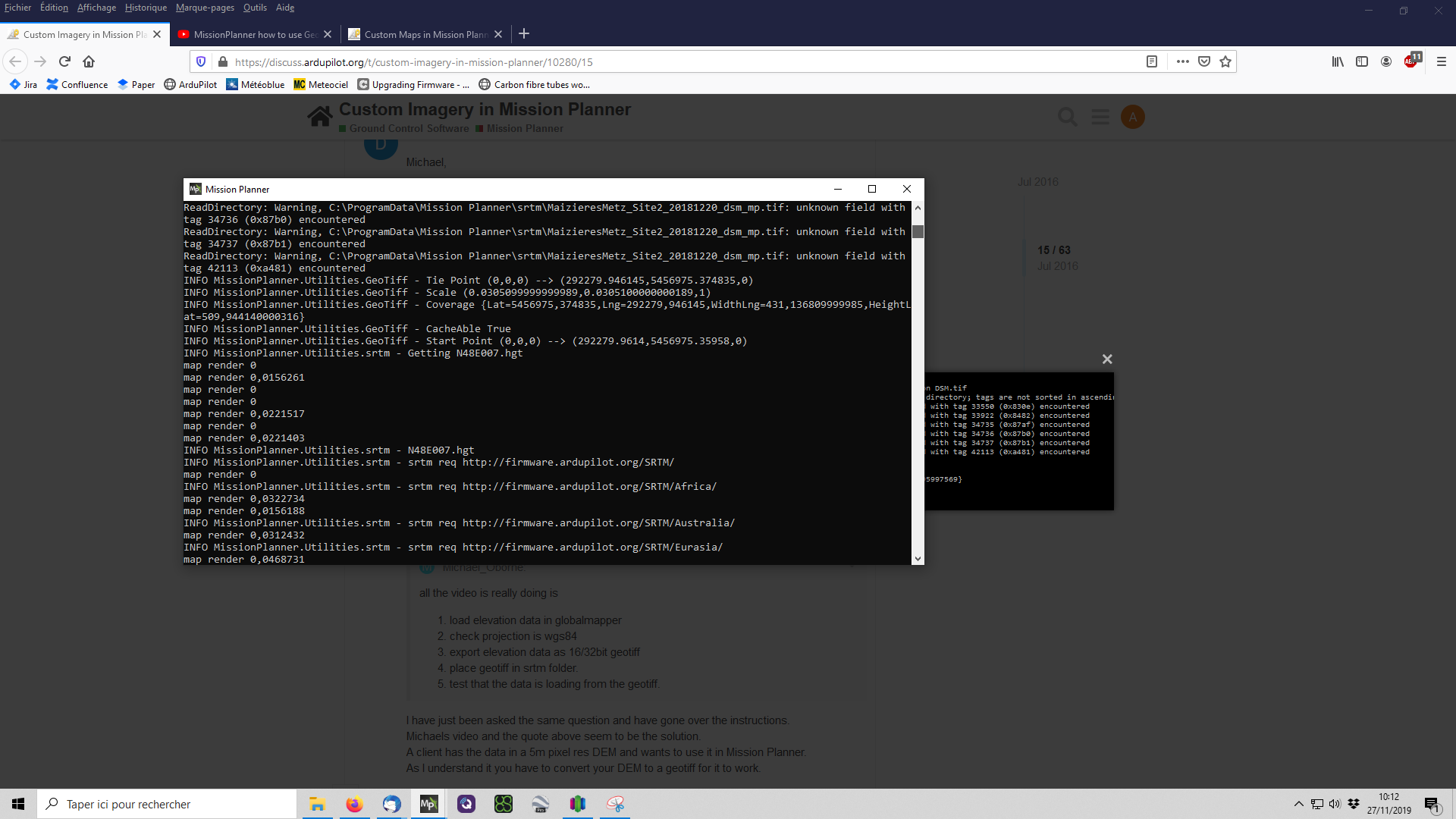
Hello thre, I have tried to get my geotiff file to be accepted in the latest mission planner.
It seems to load, but there is no altitude data.
From debug:
INFO MissionPlanner.Utilities.GeoTiff - GeoTiff C:\ProgramData\Mission Planner\srtm\2.tif
ReadDirectory: Warning, C:\ProgramData\Mission Planner\srtm\2.tif: invalid TIFF directory; tags are not sorted in ascending order
ReadDirectory: Warning, C:\ProgramData\Mission Planner\srtm\2.tif: unknown field with tag 33550 (0x830e) encountered
ReadDirectory: Warning, C:\ProgramData\Mission Planner\srtm\2.tif: unknown field with tag 33922 (0x8482) encountered
ReadDirectory: Warning, C:\ProgramData\Mission Planner\srtm\2.tif: unknown field with tag 34735 (0x87af) encountered
ReadDirectory: Warning, C:\ProgramData\Mission Planner\srtm\2.tif: unknown field with tag 34736 (0x87b0) encountered
ReadDirectory: Warning, C:\ProgramData\Mission Planner\srtm\2.tif: unknown field with tag 34737 (0x87b1) encountered
ReadDirectory: Warning, C:\ProgramData\Mission Planner\srtm\2.tif: unknown field with tag 42113 (0xa481) encountered
INFO MissionPlanner.Utilities.GeoTiff - GeoKeyDirectoryTag ID=GTModelTypeGeoKey TagLoc=0 Count=1 Value/offset=2
INFO MissionPlanner.Utilities.GeoTiff - GeoKeyDirectoryTag ID=GTRasterTypeGeoKey TagLoc=0 Count=1 Value/offset=2
INFO MissionPlanner.Utilities.GeoTiff - GeoKeyDirectoryTag ID=GTCitationGeoKey TagLoc=34737 Count=13 Value/offset=0
INFO MissionPlanner.Utilities.GeoTiff - GeoKeyDirectoryTag ID=GTCitationGeoKey Value=GCS_WGS_1984|
INFO MissionPlanner.Utilities.GeoTiff - GeoKeyDirectoryTag ID=GeographicTypeGeoKey TagLoc=0 Count=1 Value/offset=4326
INFO MissionPlanner.Utilities.GeoTiff - GeoKeyDirectoryTag ID=GeogAngularUnitsGeoKey TagLoc=0 Count=1 Value/offset=9102
INFO MissionPlanner.Utilities.GeoTiff - GeoKeyDirectoryTag ID=GeogEllipsoidGeoKey TagLoc=0 Count=1 Value/offset=7030
INFO MissionPlanner.Utilities.GeoTiff - GeoKeyDirectoryTag ID=GeogSemiMajorAxisGeoKey TagLoc=34736 Count=1 Value/offset=0
INFO MissionPlanner.Utilities.GeoTiff - GeoKeyDirectoryTag ID=GeogSemiMinorAxisGeoKey TagLoc=34736 Count=1 Value/offset=1
INFO MissionPlanner.Utilities.GeoTiff - GeoKeyDirectoryTag ID=GeogInvFlatteningGeoKey TagLoc=34736 Count=1 Value/offset=2
INFO MissionPlanner.Utilities.GeoTiff - GeoKeyDirectoryTag ID=VerticalUnitsGeoKey TagLoc=0 Count=1 Value/offset=9001
INFO MissionPlanner.Utilities.GeoTiff - GeoAsciiParamsTag GCS_WGS_1984|
INFO MissionPlanner.Utilities.GeoTiff - Tie Point (0,0,0) → (9.2415303599874,62.2202885638702,0)
INFO MissionPlanner.Utilities.GeoTiff - Scale (8.97327984480212E-05,8.97327984480212E-05,1)
INFO MissionPlanner.Utilities.GeoTiff - Coverage {Lat=62,2202885638702,Lng=9,2415303599874,WidthLng=3,97067633132494,HeightLat=2,3441796266561}
INFO MissionPlanner.Utilities.GeoTiff - CacheAble False
INFO MissionPlanner.Utilities.GeoTiff - Start Point (0,0,0) → (9.24157522638663,62.2202436974709,0)
ReadDirectory: Warning, C:\ProgramData\Mission Planner\srtm\2.tif: invalid TIFF directory; tags are not sorted in ascending order
ReadDirectory: Warning, C:\ProgramData\Mission Planner\srtm\2.tif: unknown field with tag 33550 (0x830e) encountered
ReadDirectory: Warning, C:\ProgramData\Mission Planner\srtm\2.tif: unknown field with tag 33922 (0x8482) encountered
ReadDirectory: Warning, C:\ProgramData\Mission Planner\srtm\2.tif: unknown field with tag 34735 (0x87af) encountered
ReadDirectory: Warning, C:\ProgramData\Mission Planner\srtm\2.tif: unknown field with tag 34736 (0x87b0) encountered
File:
https://drive.google.com/u/0/uc?id=1e9t_Du2tnUDcuIj7Pm1Zpfs3qI0LF6Aa&export=download
That files is converted by a friendly person, since I do not have access to Globalmapper.
Related:
so your tiff is actualy ok.
the issue is that its 4.5gb.
ive made some changes in beta MP to improve the performance, however its still not instance, because the file is so large.
ive also added support for 32bit integer. as i expected 32bit float. i will push a new beta version in the next hour or so
Hey Michael,
Can we increase the resolution past zoom level 21? I see you upped it many years ago to this number, but I have some custom maps that could work at 24.
Thank you!
how are you feeding in the images? wms?gdal? etc?
ie atm
wms = 22
gdal = 24
I’m using google maps ties, couldn’t get geotiffs to work, let me try with some renewed enthusiasm now that I know I can use gdal up to 24 (thanks!)
also google tiles dont go to 24.
Hi @Michael_Oborne
Immediately below is the error code from debug - finally found that. The TIFF is from drone deploy- definately WGS84 - I though from the error maybe not 32bit.but file confirms it is
ERROR MissionPlanner.Utilities.ParameterMetaDataRepositoryAPMpdef - System.UnauthorizedAccessException: Access to the path ‘C:\ProgramData\Mission Planner\SITL.apm.pdef.xml’ is denied.
at System.IO.__Error.WinIOError(Int32 errorCode, String maybeFullPath)
at System.IO.FileStream.Init(String path, FileMode mode, FileAccess access, Int32 rights, Boolean useRights, FileShare share, Int32 bufferSize, FileOptions options, SECURITY_ATTRIBUTES secAttrs, String msgPath, Boolean bFromProxy, Boolean useLongPath, Boolean checkHost)
at System.IO.FileStream…ctor(String path, FileMode mode, FileAccess access, FileShare share)
at MissionPlanner.Utilities.ParameterMetaDataRepositoryAPMpdef.<>c.b__6_1(String a)
ERROR MissionPlanner.Utilities.ParameterMetaDataRepositoryAPMpdef - System.UnauthorizedAccessException: Access to the path ‘C:\ProgramData\Mission Planner\AP_Periph.apm.pdef.xml’ is denied.
at System.IO.__Error.WinIOError(Int32 errorCode, String maybeFullPath)
Hoping you are able to assist in getting this tiff to load into planning screen
Kindly
steve
Hi Michael,
I am looking to integrate the map from the attached link it is about 313MB which I figure is to large to be easily be uploaded, though I do believe it is being used for SRTM data ( as tif takes preceedance)
I would like to be doing this on a regular basis - and be interested what is a good sized file so to set my resolution accordingly when building the map ~200acres for regular use.
Kindly Steve
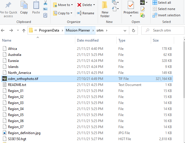
Hi Micheal. I’ve been trying to carry out this same task. I have tried uploading this same Geotiff file onto mission planner by saving it in the SRTM folder, just like the screenshot you uploaded. But unfortunately, It still does not show up on the plan page. Could you let me know what the problem might be?
I’m using version 1.3.75.1 build 1.3.7.998.11596.
Thanks in Advance
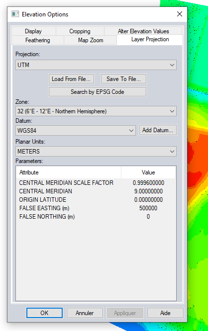
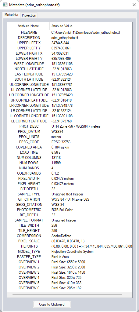
ok so this is what global mapper tells me
its in UTM zone 56S
its also not elevation data/dtm, its a raster geotiff, so the srtm folder should not be used, as this is for elevation data only.
you need to use the custom gdal image source to use this image as Map data
I’m getting an weird error with some tif files while others load just fine.
INFO MissionPlanner.Utilities.GeoTiff - GeoTiff C:\ProgramData\Mission Planner\srtm\test.tif
ReadDirectory: Warning, C:\ProgramData\Mission Planner\srtm\test.tif: invalid TIFF directory; tags are not sorted in ascending order
ReadDirectory: Warning, C:\ProgramData\Mission Planner\srtm\test.tif: unknown field with tag 34264 (0x85d8) encountered
ReadDirectory: Warning, C:\ProgramData\Mission Planner\srtm\test.tif: unknown field with tag 34735 (0x87af) encountered
ReadDirectory: Warning, C:\ProgramData\Mission Planner\srtm\test.tif: unknown field with tag 34736 (0x87b0) encountered
ReadDirectory: Warning, C:\ProgramData\Mission Planner\srtm\test.tif: unknown field with tag 34737 (0x87b1) encountered
ReadDirectory: Warning, C:\ProgramData\Mission Planner\srtm\test.tif: unknown field with tag 42112 (0xa480) encountered
ReadDirectory: Warning, C:\ProgramData\Mission Planner\srtm\test.tif: unknown field with tag 42113 (0xa481) encountered
INFO MissionPlanner.Utilities.GeoTiff - tiff ID=GEOTIFF_MODELTRANSFORMATIONTAG ? 34264 len=2
INFO MissionPlanner.Utilities.GeoTiff - tiff ID=34735 ? GeoKeyDirectoryTag len=2
INFO MissionPlanner.Utilities.GeoTiff - tiff ID=34736 ? GeoDoubleParamsTag len=2
INFO MissionPlanner.Utilities.GeoTiff - tiff ID=34737 ? GeoAsciiParamsTag len=2
INFO MissionPlanner.Utilities.GeoTiff - tiff ID=42112 ? GDAL_METADATA len=2
INFO MissionPlanner.Utilities.GeoTiff - tiff ID=42113 ? GDAL_NODATA len=2
INFO MissionPlanner.Utilities.GeoTiff - GeoKeyDirectoryTag ID=GTModelTypeGeoKey TagLoc=0 Count=1 Value/offset=2
INFO MissionPlanner.Utilities.GeoTiff - GeoKeyDirectoryTag ID=GTRasterTypeGeoKey TagLoc=0 Count=1 Value/offset=1
INFO MissionPlanner.Utilities.GeoTiff - GeoKeyDirectoryTag ID=GeographicTypeGeoKey TagLoc=0 Count=1 Value/offset=4326
INFO MissionPlanner.Utilities.GeoTiff - GeoKeyDirectoryTag ID=GeogCitationGeoKey TagLoc=34737 Count=7 Value/offset=0
INFO MissionPlanner.Utilities.GeoTiff - GeoKeyDirectoryTag ID=GeogCitationGeoKey Value=WGS 84|
INFO MissionPlanner.Utilities.GeoTiff - GeoKeyDirectoryTag ID=GeogAngularUnitsGeoKey TagLoc=0 Count=1 Value/offset=9102
INFO MissionPlanner.Utilities.GeoTiff - GeoKeyDirectoryTag ID=GeogSemiMajorAxisGeoKey TagLoc=34736 Count=1 Value/offset=1
INFO MissionPlanner.Utilities.GeoTiff - GeoKeyDirectoryTag ID=GeogSemiMajorAxisGeoKey Value=6378137
INFO MissionPlanner.Utilities.GeoTiff - GeoKeyDirectoryTag ID=GeogInvFlatteningGeoKey TagLoc=34736 Count=1 Value/offset=0
INFO MissionPlanner.Utilities.GeoTiff - GeoKeyDirectoryTag ID=GeogInvFlatteningGeoKey Value=298.257223563
INFO MissionPlanner.Utilities.GeoTiff - GeoAsciiParamsTag 34737 WGS 84|
ERROR MissionPlanner.Utilities.GeoTiff - System.NullReferenceException: Object reference not set to an instance of an object.
   at MissionPlanner.Utilities.GeoTiff.geotiffdata.LoadFile(String filename) in C:\Users\mich1\Desktop\CubePilot\MissionPlanner\ExtLibs\Utilities\GeoTiff.cs:line 208
   at MissionPlanner.Utilities.GeoTiff.generateIndex() in C:\Users\mich1\Desktop\CubePilot\MissionPlanner\ExtLibs\Utilities\GeoTiff.cs:line 515
Any idea what could cause it? Here’s the tif file: test.tif - Google Drive