did not know i could Lol
if i can dump it all in the folder its all good
yes, simply dump all your locations in same folder, you’ll notice all paths are different!
its ethos that doing it i just update my last x12s to ethos
any hints on how to replicate?
all i do is go to the map page that all it shows
ok now i changed model and its fine ![]()
thanks @Hoehenarbeit for QGIS ! 5x less SD space is great with JPG and download is conveniant. @yaapu I tested the new layout with QGIS addition and it seems to be perfect, one more time !
What an essential companion to arduplane ![]() About QGIS map, I wonder if gps location could be off from 5-10 meters ? I need to test on my others plane to see if it’s not a GPS inconsisentcy due to my GPS or weather condition.
About QGIS map, I wonder if gps location could be off from 5-10 meters ? I need to test on my others plane to see if it’s not a GPS inconsisentcy due to my GPS or weather condition. ![]()
Hi David, is there an easy way with QGIS to download map data for a specific point with x km radius?
Not that I know. You can only download rectangular maps, where you have to provide the 4 coordinates of the corners. However you can calculate this based on the center coordinate and the “radius” as an offset. I could provide a formula when I’m back in the office, but it’s quite easy to find on Google.
Hi, google and qgis use the same gps reference system so I would assume no offsets.
In the guide @Hoehenarbeit kindly provided there’s a step to make sure QGIS is set to wgs84 which is the same used by MissionPlanner when downloading google maps tiles.
Hello! This may be a silly question: I run a FrSky Archer R8 Pro receiver (newest firmware) with an X10S TX with Yaapu. I do not receive telemetry data however. I do have controls, for example RC calibration in Mission Planner works. Serial protocol is 10 (FrSky SPort Passthrough OpenTX). Does anybody know a solution? Thanks in advance!
Hi, in order to help you we need more context, what’s your flight controller and which ardupilot version are you using?
How about the wiring?
Thanks for answer. I correctly set tiles to epsg :4326 (wgs84) as explained in the guide. I will check again in next days. Regards.
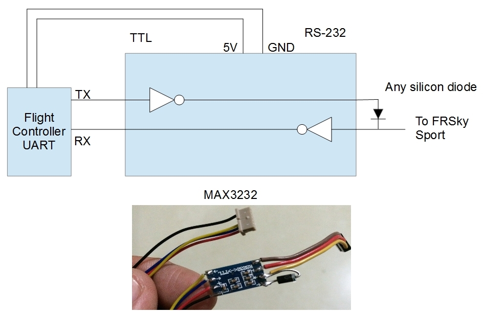
Hi, we use Cube orange, ArduCopter V4.3.3 and this cable https://ardupilot.org/copter/_images/DIY_SPort_Cable.jpg
Works well with every other drone, the only thing that is different is the receiver, we normally use an FrSky X8R and not an Archer R8 Pro. Binding worked flawless btw.
EDIT: Just checked, everything (Cables, TX, Parameters) is working on another drone with the X8R. So the problem must be connected to the Archer R8 Pro.
did you check this out?
Hi all,
on github I released a dev version (please download zip from the master branch) which among other tweaks/fixes
- supports FlySky NV14 and EL18 radios
- supports QGIS as mapping provider
- supports ArduPilot aerobatics trick audio call outs (trick # selected and aborted)
feedback is welcome
2 Likes
\WIDGETS\yaapu\lib\layoutlib.lua IS MISSING!!!
1 Like
auch…sorry, fix asap
fixed, sorry about that