You can specify a lof of settings. The documentation about the export feature is here. You can find the code for the generation here.
I exported as an example Google Sattelite Hybrid map you requested between zoom levels 20 and 25. I only changed the tile size to 100x100 and provided this extent: 149.1646107,149.1658573,-35.3641628,-35.3623628 [EPSG:4326]. Download
Exported tiles use https://leafletjs.com as web rendering engine.
I’d say we are lucky, the example you generated uses tiles which are 1:1 to google tiles which I suppose was the selected map provider, tiles path coordinates are reversed in respect to what missionplanner uses but no big deal, I’d say that a least up to zoom level 20 should be doable with a reasonable effort.
Note: zoom above 20 is “virtual” (forged by qgis by zooming in on google images) so need to check if the above conclusions hold true
The tiles output is not coupled to the map provider. You always get the same format regardless of what map you are using. It can be an online service, but you can also use offline files like a georeferenced geotiff and much more.
Here is for eg. Bing in zoom levels 19-20: bing.zip (876.6 KB)
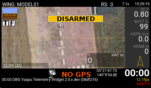
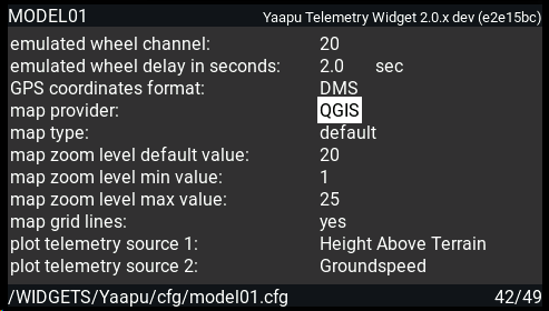
under “map type” use default (path is SD/IMAGES/yaapu/maps/qgis_default/…) or the layer 1,2,3 options to have alternative maps under SD/IMAGES/yaapu/maps/qgis_layer[1|2|3]
unfortunately no, you’ll have to fork my project and add a page that way, or make a pr for a readme.md file in the MAPS directory that I will transform in a wiki page later?
I hardcoded PNG as file format for qgis, we can switch to jpeg if required, let me know the best option and I’ll change the code, I don’t want to make it an option to prevent unnecessary support questions
Please try it and tell me if anything is unclear or you need any more detail. Feel free to experiment with the various parameters like JPG quality, DPI, Metatile size, etc. Not sure how they effect anything.
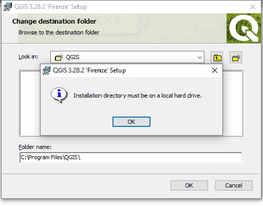
You could also try installing via the OSGeo4W Network Installer (same link as in the wiki). Choose Express Install and only select QGIS LTR to install the long term release. There must be a solution to your problem.
Morning Alex can we add to the yaapu config to able to select gps map folder for different areas
some of my flying areas over 200 km apart
what i have been doing chaining the fold to that area before i leave home some times i don’t take laptop
and if i forget yesterday after 2 hour drive fire up the drone bugger i have no map data
Hi Colin, not sure I understand, why can’t you pack all your tiles in a single directory, there are no limits and tiles will never conflict with each other since the path of each tile on the filesystem is based on zoom and gps position