I want to put LVDS signal on the motherboard directly into HDMI signal, and then through the data transmission back on the line, if the bandwidth is too big, directly converted to analog signal back may also be feasible.
Please update us on how you go with the LVDS signal method. I don’t know that much about electronics and video signals.
Through literature review, I know that there are two kinds of video signals, one is TTL and the other is LVDS. A few days ago, I found a module converting these two signals into HDIM signals on our TAOBAO website. If I can get HDMI output, then I can use 433 wireless image transmission to transmit the signals to the local.
I bought a new LOWRANCE hds7 yesterday with a new 3-in-1 radar. I want to map out the interface. How should I do it properly?
Which interface do you want help with ?
both about 4G connection and wifi connection,thank you !
For lowrance HDS to PC display sonar data - we need basic IP connectivity - eg can you ping ? This is pretty straight forward for wifi, but little bit more tricky for 4g depending on the provider.
Perhaps some others can provide different 4g control solutions to my suggestion - eg proxy methods etc. The below is a little technical but if you understand networking, it may make sense.
Heres my knowledge on how to get 2 x 4g router devices to talk to each other. Basically we just want a vpn tunnel between the 2 routers - so your laptop can ping over 4g to the lowrance on the water.
- Easiest if at least one has public IP and allows inbound VPN connections.
- However many 4g providers provide private IP only - and NAT at the carrier level.
- Really depends on each provider and which APN you connect to.
Heres a list of australian providers - and if they have public IP or not
https://whirlpool.net.au/wiki/publicip
Worst case, you can’t get public IP on either 4g router, then you would need to tunnel both the ground station and boat 4g connections to a 3rd router with a public IP - eg your home internet.
Heres a video of my boat in action

2 Likes
I am quite familiar with the operation of routers, so my idea is that if a 4G router can be used to construct a network including sonar, and the DMZ host is set as the IP address of sonar, then I can use software to connect to the sonar remotely, I don’t know if my understanding is correct.
Yes your understanding is correct, however the only issue will be if your 4g cell provider doesn’t assign public IP to the WAN interface of the router. Many 4g providers use internal addresses - eg 10.x on the WAN side.
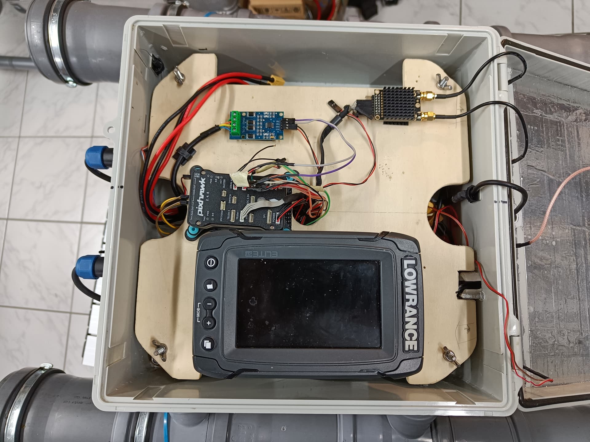
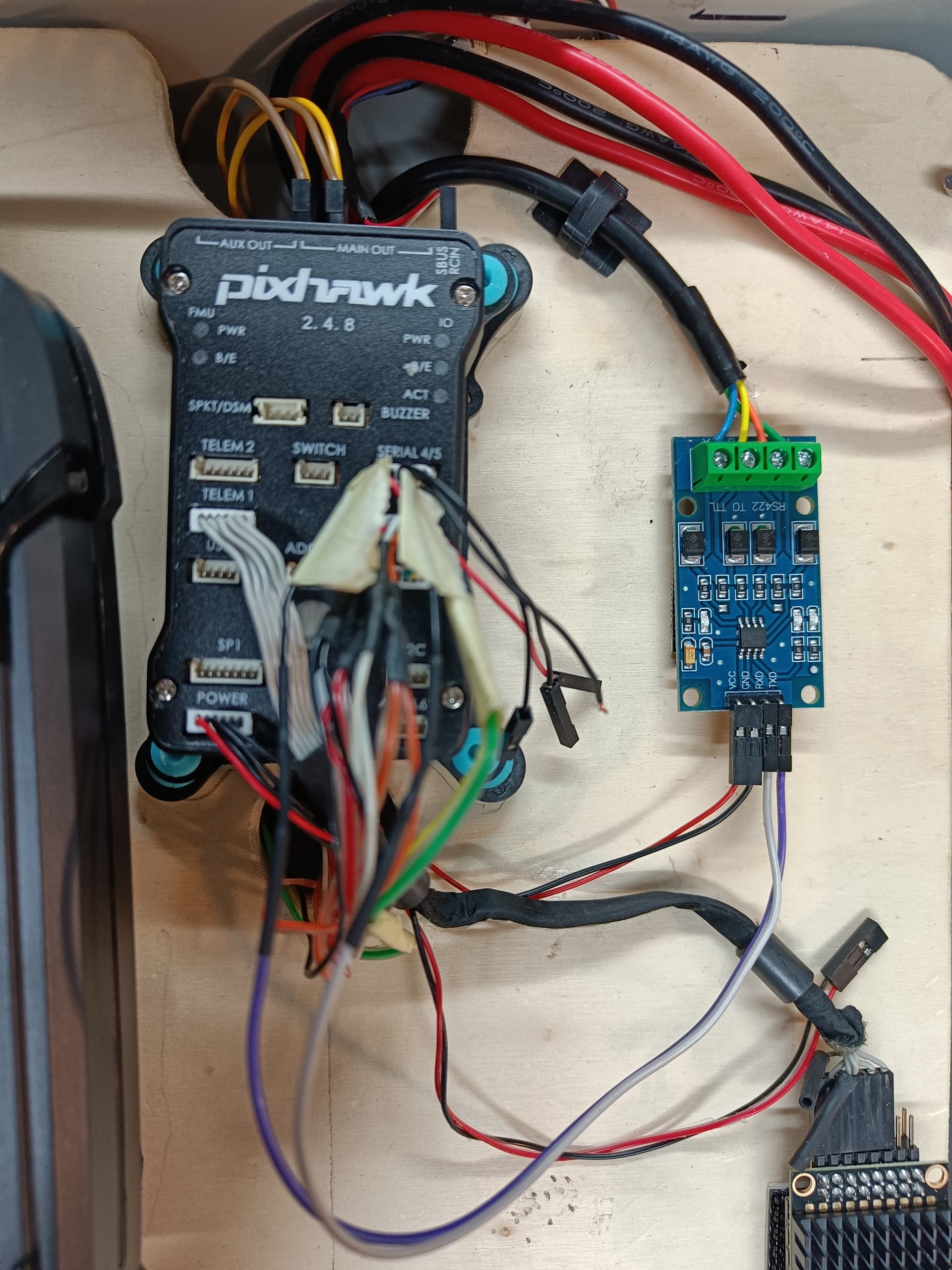
Thanks again for your work and help. Thanks to your detailed descriptions I was able to finally get a GPS input from my pixhawk into lowrance.
I didn’t test it on the water yet, but it indeed seems that it works bidirectional and I also get depth readings in missionplanner.
I don’t know where I went wrong but it seems that I simply confused some tx/rx wirings.
Finally I could get it to work though.
Appreciate your help and can recommend this guide.
I used an old lowrance elite ti (version one, 7 inch). Which means it should work with just about any lowrance.
Great result.
I too couldn’t get it working and took me a while to work out the wiring combo that works.
Hopefully we can get the diagram in the wiki fixed @rmackay9
I tried to propose a change on git - but not sure what I’m doing and it says
The ‘ArduPilot/ardupilot_wiki’ repository doesn’t contain the ‘common/source/_images/lowrance-elite-ti2-sonar.jpg’ path in ‘master’.
@rmackay9 i think by now there is quite a confusion about different topics all talking more or less about the same: connecting pixhawk/cube/whatever to a lowrance sonar. at least i have difficulties keeping track of the different threads and their discussions. i took the liberty to tag you here, because this thread solves all the others. (e.g. Lowrance NMEA 0183 to Cube Orange - #30 by RDodds )
i followed the guide from @aussiemaverick and can only say that it’s spot on. it works with my old elite ti version one (7 inch) which is known not to be very happy to take inputs, doesn’t support nmea2000 or ethernet. hence why i think that this guide works for just about any lowrance sonar.
the problem is solved thanks to his efforts. and he also found out that the wiki (Lowrance Elite Ti2 Sonar — Rover documentation) is wrong, which i definitely second.
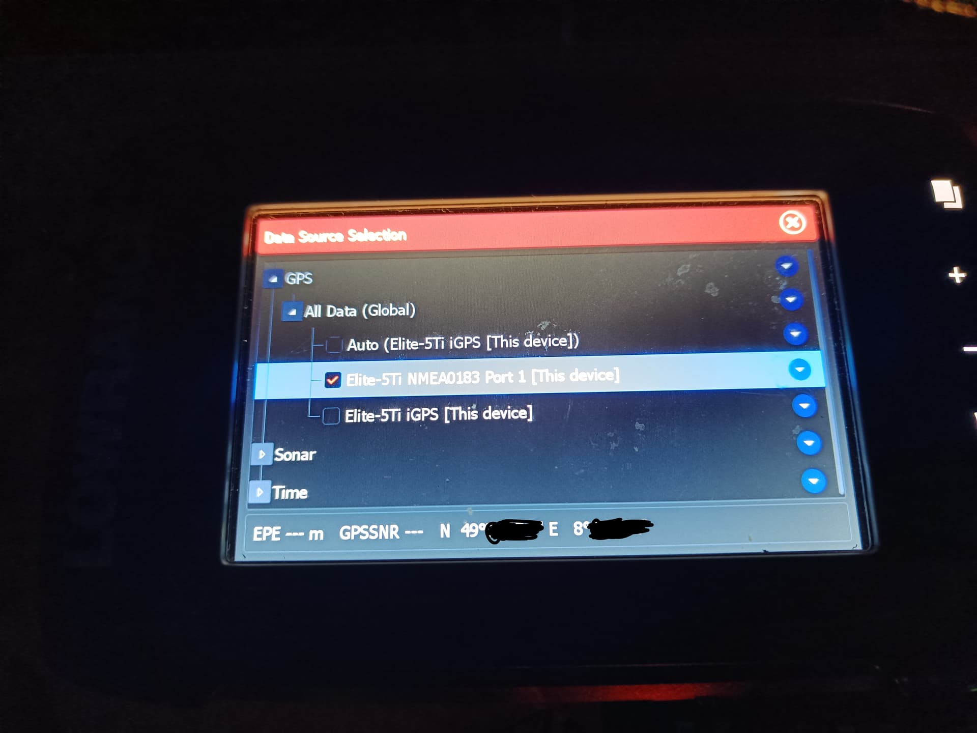
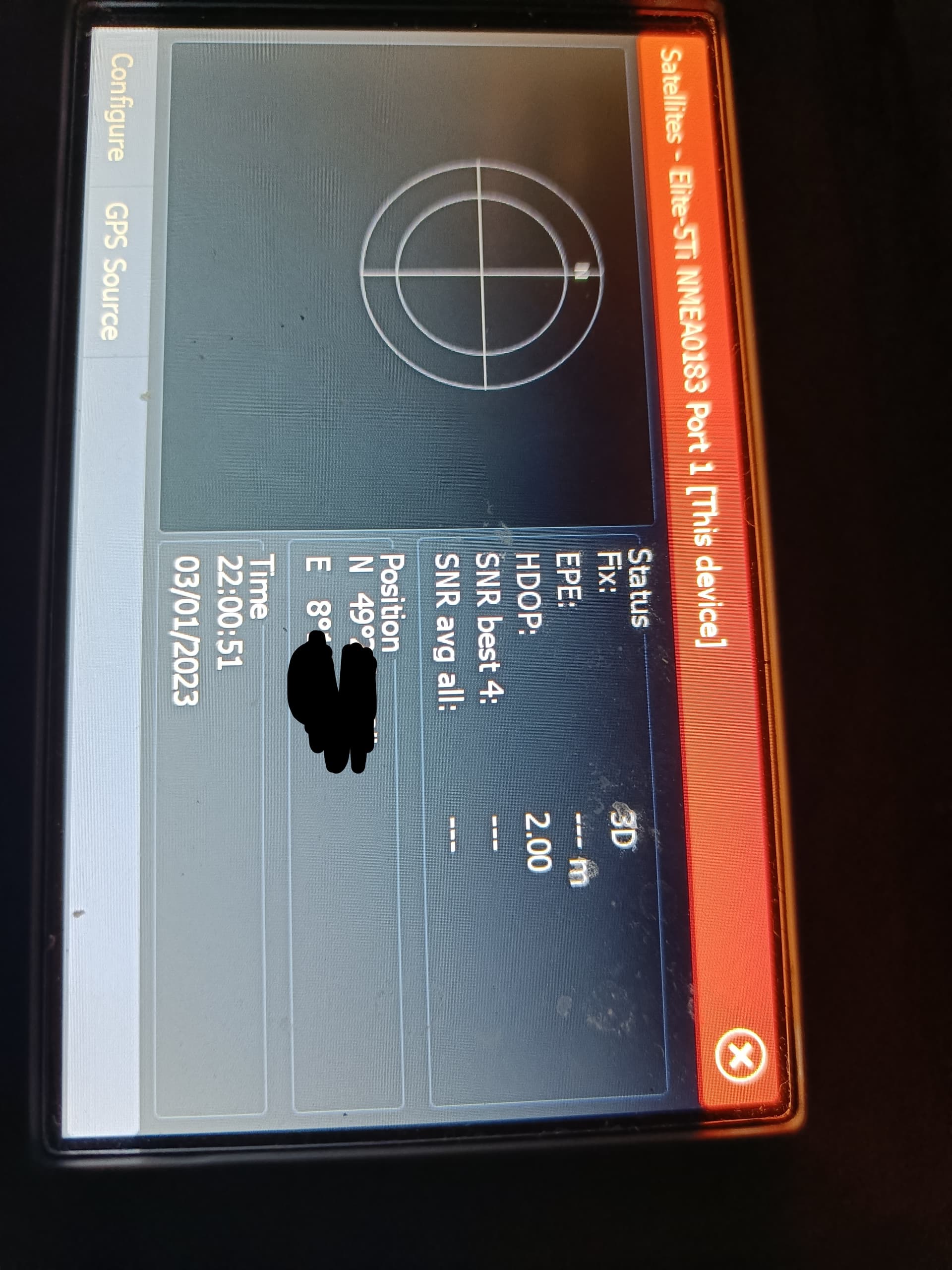
i tried feeding my lowrance with gps data going by the wiki and couldn’t get it right. it turns out that the green and orange wire were mixed up.
is there a way we could update the wiki with his new description? also get rid of the title (“lowrance elite ti2.” since it also works for hds or elite ti1 etc.)
we’re able to have bidirectional depth and gps quite easy with just an rs422 connected to serial4/5.
only thing i’m not sure about: when i first hooked up everything right, my lowrance did not recognise the external gps. i did 2 things then: restart the pixhawk and activate depth output on lowrance. so it might be that it only works when lowrance also outputs NMEA DPT sentences.
please tell us if you want us to rewrite the wiki.
cheers
1 Like
Wow thanks for the feedback @Holly918
Makes me feel good to contribute back to the group and actually fix some things that never seemed to work for ppl.
My suggestion is to just update the wiring diagram on the existing Ti2 Sonar doco - since the rest of the doco is fine. I’ve actually done the updated diagram on that thread, but I get an error when I try to edit it in git.
Lets do a 2nd wiki page for the bi directional config (covering both HDS and Ti2 Sonar).
1 Like
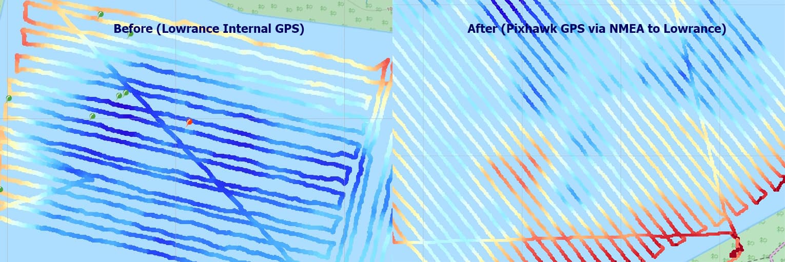
i just came home from another mapping mission and tested the GPS NMEA stream to lowrance for the first time.
it works perfect. finally i have parallel sonar tracks that i can combine to a sidescan mosaic. ![]()
2 Likes
Wow looks so much nicer now that your sharing the GPS. What mapping software do you use to generate the images ?
I use reefmaster to combine the tracks to a nice visual map. And a little bit of Photoshop for my own logo and stuff.
2 Likes
@aussiemaverick i have read through all of your topics and replies relating to integrating the Lowrance HDS with an AP. I am trying to transmit live Lowrance HUD to a base station PC like you have done over 4G however I am not savvy in networking at all and have been struggling. I have you come around to writing a detailed overview on how you have achieved this with 4G?
Fantastic work here gentleman, I can concur, the previous posts have never worked for me. Look forward to testing this. I use Humminbird mostly which works well on the older units but the new ones have the same protocol issues as the newer Lowrance units so hopefully this sorts it out.
1 Like
Hi @kojirov
Have a read here so you can understand the simple wifi method.
Lowrance HDS stream full sonar to PC / mission planner - ArduRover / ArduBoat - ArduPilot Discourse
Using wifi its simple - the PC and HDS will be on the same network and same IP range.
4G/ 5G can be more complicated because of two reasons
- now the PC and HDS are not on same lan and need internet connection between them
- often 4G providers don’t assign a public IP address to your 4G router (instead they use carrier NAT)
If you 4G/5G router gets a real public IP address, you can use common port forward / server publishing configuration in the router to advertise TCP 554 to the internet. And then on VLC or mission planner - use the public IP of the router to connect to the stream.
Another method is to use a VPN on the 4G router to connect back to your PC network. A VPN may help the carrier NAT problem, and also help if the 4G connection is changing IP addresses.
There is many other options too, including proxy, and other providers etc. So the answer isn’t - one size fits all for 4G/5G connections.