I want to use three things: optical flow, LIDAR, and ZED with TX2

Hello.

First, since I do not live in a country where English is spoken, I would like to say that the level of English is low.
If you don’t understand my question, please leave a comment. Thank you :joy:

As the title suggests, the goal is to have a stable hovering in the GPS shaded area.

First of all, I knew that an optical flow, Lidar sensor is needed for indoor flight, and I tried it already, and I flew safely.
Now i want to go one step further and use ZED and TX2 for reliable hovering without GPS.
As I saw the related information in wiki, I confirmed that to use ZED, disable EKF2 and activate EKF3.

image

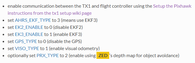
If I understand correctly, does disabling EKF2 mean that it does not use all parameters associated with EK2_xx with Optical flow, Lidar?
So, if i follow wiki, when i use ZED its only fly in outdoors (in an environment without GPS) and cant fly indoors? (Because cannot use a range finder such as lidar)

To sum up, my ultimate goal is to fly under bridge and indoors, and I think all ZED, optical, and Lidar should be available for that, but is this not possible?

In addition, wiki is disable GPS when set up optical or zed.
If i activate GPS, don’t the sensors work?
In the environment in which the GPS operates, use the GPS. Then, if GPS flies to areas where it doesn’t work, I want to use sensors to fly.

Thank you for reading my question.

@juibn,

Getting non-GPS navigation working really well is still a bit of a work-in-progress. The options are listed up here on the wiki. My feeling is that the best long-term solution is Google Cartographer on a TX2 with a 360 lidar.

Some answers to your questions:

  • yes, disabling the EKF2 means all EK2_ parameters are not used
  • ZED can be used indoors or outdoors
  • I’m afraid that optical flow and ZED (visual odometry) cannot be used together because they both provide the same type of information (velocity info).

@rmackay9

thank you for reply.

if use ZED when i fly indoor, i think need Lidar or sonar for altitude measurements.
So are ZED and LIDAR available at the same time?
If available, what parameter should be modified?

Thank you. Have a good day.

@juibn,

Yes a lidar or sonar might help for the altitude control because it will be more stable than the barometer over long periods of time. ZED and downward facing lidar can be used at the same time. RangeFinder setup instructions are here on the wiki.

@rmackay9

Thank you for reply.

i will try ZED and Lidar.
Thank you for help :slight_smile:
It was an honor for you to let me know.

1 Like

@rmackay9

Let me ask you one more question.
Can I use GPS with ZED and LIDAR at the same time?
Do I have to disable GPS?

@juibn,

It’s untested but it should be possible, if using the EKF3, to use all three at the same time. The limitation is that the EKF can’t accept data from two different sensors providing the same type of data. So for example a GPS and a Beacon system both provide position so they can’t be used together. GPS + ZED is fine though because the GPS provides position while the ZED provides velocity. The Lidar data doesn’t go into the EKF so it’s not an issue at all.

@rmackay9
Thank you :slight_smile:

1 Like

@rmackay9

happy new year.

can i ask one more question?

ZED+TX2 Non gps function is also support object avoidance?

For example, if an object is detected, it might stop there?

@juibn,

Yes, but to be clear, the ready-to-go APSync image that includes OpenKai is only available for the tx1. We just didn’t get quite enough info from the OpenKai guys to get an image ready for the tx2.

Hi @rmackay9
Is there a software can replace OpenKai on TX2? Because our project needs to ZED+TX2 non-gps navigation to indoor flight.
Thanks

@yoga,

I’d recommend using the Intel Realsense T265 and GPS/Non-GPS transitions available in our latest development code (Copter-4.1.0-DEV).

I think it should be possible to use the ZED+TX2 but I’m afraid we don’t have an up-to-date image available for this. I suspect that it will be easier to get the ZED’s local position estimates flowing into ArduPilot using ROS+mavros but I can’t give too much advice on how to do this.

@rmackay9,

Thanks for your advice, but it may not fit our requirement because we use drounekit to control the drone not ROS.

Is this still true as of Copter 4.3.7? Or is it now possible to have two sources providing the same type of information (velocity info) by setting EK3_SRC_OPTIONS = 1 (FuseAllVelocities)? I’m also interested in running visual odometry and optical flow at the same time.

@Mateus_Ferreira,

Yes, as you say, with more modern versions of ArduPilot running EKF3 (probably 4.1 and higher), multiple sources of velocity information can be used together by setting EK3_SRC_OPTIONS = 1 (FuseAllVelocities).

There are three lua scripts linked from the GPS/Non-GPS Transitions page and one of them includes visual odometry and optical flow. That was designed for the T265 so it might need some modification but hopefully it’s a good start.

1 Like