How do you create the .csv Files?
I use a batch file to convert the .bin File:
python sdlog2_dump.py %DATEI%.bin -e -f %DATEI%.csv -m GPS -m ATT -m NTUN -m CTUN -m MODE -m BAT -m RCIN -m RCOU -m BARO
Since a long time ago I get always 3 error lines like: Warning:Unsupported format char: a in message ISBD (180)
But the .csv File works in Dashware.
sdlog2_dump.py is an old tool from PX4 days.
MissionPlanner has an up-to-date feature to generate the csv file from a dataflash log.
It should be documented in Henry’s new wiki entry.
A complete how to is in the wiki of that repo
And btw there are two tools that are really user friendly when analyzing logs and they are web based:
Dronee Plotter : plot.drone.ee
and
TLogViewer (does bins also): http://tlog.ibexcps.com which is still in development but its looking really good and is usefull as is now…its a little slower because it runs in your PC locally even though its a web interface…but thats actually good since the server will never bog down
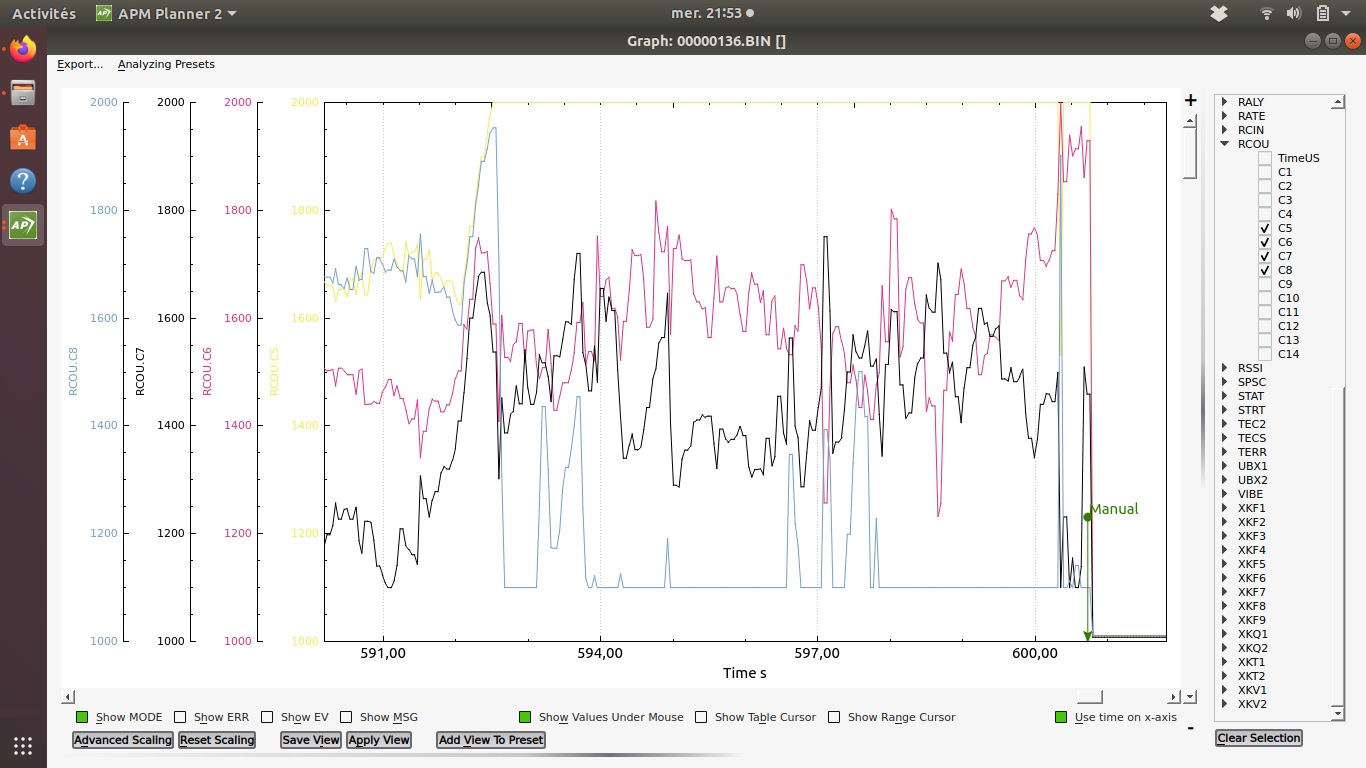
About log analysis: this evening I crashed my biwing, I was flying qacro for the 2nd time and tuning was perfect, suddenly I lost control and plouf again… Plouf is in french the noise that makes water when something dive 
I looked at the log and found the rcout C5 (bottom left) to be at maximum value and rcout C8 (top right) at minimum. That looked like a burned ESC so I looked at it and found a broken solder joint on the power line. Shame on me… 
This is the end of my biwing as water is everywhere and I have to make too much damage to remove and dry electronic.
I still have my waterproof blackfly to complete, I hope it will fly as good.
 sorry for your loss
Sorry for this, but at least you found the reason. We say, one error eliminated is one possible failure less.
The noise in swiss-german is called: Platsch.
Good luck for your blackfly.
Thanks for the hint. I searched in the MP, but at the wrong place.
Thanks for your help, I was wondering why this conversion was not integrated in MP.
I use Dashware for a long time for a better analysis of the flight. (Visual and Log together)
e.g. in post Copter Tailsitters - #592 by lorbass
To have the wing always in sight, I use this 3D printed Gopro camera mount. When you are interested, I can upload the STL (white part only)
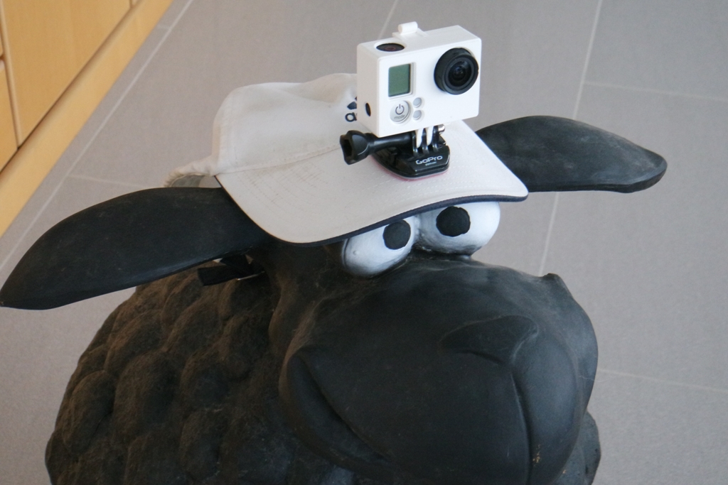
Thanks…when I had GoPros, I had a head mount also…but since almost 100% of my flying is by FPV I usually dont do ground based videos…my HD cams for planes are RunCam 2 and 4 now…so for ground videos I use my pocket 35mm camera
Thanks for the link with the plot.drone.ee. Really good for analizing.
Im still fighting to finde the reason for the Yaw/Roll instablity of my copter Tailisistter Plus when in QHover forward flight with pitch 30°
TlogViewer is better since it allows mixed graphs and you can align the left axes by dragging them up and down…also nice 3D plot…works well but occasionally has a glitch…I am moving from Dronee to that…is a bit slower since it runs on your PC and not the Webserver host…but being able to have one graph with different messages is nice, as well as clear MODE regions, like mavexplorer
BTW nice photo…you need a haircut though 
Hairdresser locked down due to corona.
When I click your link about TLog… I get a clear, black screen with Firefox.
Sorry to hear that the biwing has drowned 
But I’m glad the firmware isn’t to blame, and I think the waterproof option is a great idea.
I’ve never done worse than break props crashing my AquaQuad into water, although you wouldn’t want to hit the water too hard with something like the blackfly.
I just clip my (imitation) GoPro to the back band of a baseball cap and wear the cap backwards.
The downside is no visor.
BTW, didn’t know you were so pretty!
The advanced scaling option in APMPlanner2 lets you customize color and group traces for scaling, although it still displays a Y axis for each trace in the group. And it can export to KML so you can plot vehicle attitude in Google Earth like this:
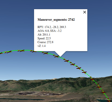
what is AOA and SSA?
angle of attack and sideslip angle
Sorry, still black screen, even with Micrsosoft Edge.
The csv File from MP doesn’t work with my DataProfiles. The blue heading Map works, but all other values jump around as if the Linear Interpolator would not work. Could you tell me, how to download your example DataProfile to compare it?
Or is it nescessary to mark all lines and to copy/paste it? ![]()