Hi, I am using SITL to validate a new configuration since HITL was discontinued. I have a few questions about altitudes:
-
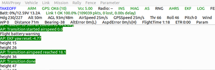
what are the altitudes on the Arduplane Console (see attached image)? I them as (left -> right) m AGL<height relative to origin + offset, using baro 1> / <height relative to origin + offset, using baro 2>, where ‘offset’ is my second question.
-
You can set the base altitude in MAVProxy->Settings->third tab over. What does this do? I cannot find documentation for it. It offsets one of the three altitude readouts as shown above.
-
Can you fail the altimeters in SITL? I tried with ‘param set sim_bar2 disable 1’ and 'param set sim_baro_disable 1 but wasnt seeing the behavior I was expecting? Does GPS take over automatically?
Thanks!
Ed