Okay, so firstly I am finding this forum a fantastic wealth of information and I thank each and every one of you for what I have learned thus far and hope that one of you is able to help me. I am a mechanical/ mechatronic engineer by trade, however my specialties do not ly in pure coding and programme writing. Therefore I am at a loss with my research. Bear with me, I’m not good at typing prose and getting my story across
I have built Pixhawk copters before and am familiar with the waypoint navigational methodology.
As in other topic threads (Agricultural Rover project) a number of us are looking to make rovers which run off the ardupilot platform.
This can be done more “normally” through the traditional waypoint navigation as Kenny Trussell has done with his automated mower. However as pointed out, this is not as slick to use in a semi-autonomous setting where the ardupilot is being used as an autosteer tool with a user in the cab.
For this people have used other platforms such as open ag gps. However these do not provide the level of IMU integration and sophistication of the “drone tech” which I would like to use. Equally for ease of build, a pixhawk 2 with built in redundancies etc is a complete package whereas running the whole lot of an arduino will be slower and less reliable. The user interface of running this system is where this falls down.
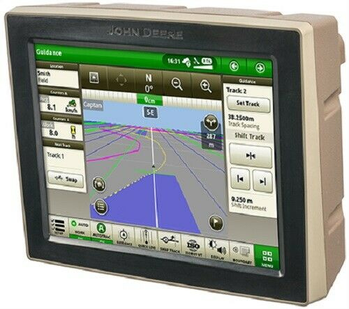
I am wanting to create an android based app which can be used in the cab of a tractor as an HMI similar to the interface for Cerea or any commercial agricultural autosteer such as John Deere Green Star
BUT integrate this somehow into the ardupilot GCS in order to create AtoB lines and paths etc etc such as a “traditional” autosteer product.
Im hoping that this could be done somehow using MavLink to give instructions to the GCS running in the background. I can learn the nessesary stuff to create an app and write some programme if someone could point me in the right direction of the correct rabbit hole.
Im not sure if I am being clear in what I am asking for so if you have any questions throw them at me.
Thank you in advance for your time, patience and help.
The idea of and Android app Is great but I’m not sure to have understood very well your topic.
I’m a Cerea user and I know how does it work but if you are in the tractor cab why do you need to use a GCS?
I have the vehicle able to operate completely autonomously using mission planner, a pixhawk and Emlid RTK. This achieves my fully autonomous features. This is great until I want to have an operator in the cab for a more traditional Autosteer experience.
so going backwards a little…
To have an HMI with the options available such as an A to B line etc such as Cerea.
Either using Cerea software or a new android app, giving instructions or waypoints to the pixhawk flight controller which is controlling the rover outputs.
Are you suggesting I could use the Cerea software (on a windows tablet) running inputs and outputs on a pixhawk flight controller and Emlid GPS hardware? Connecting the Cerea to the pixhawk via the telemetry link, either wirelessly or wired should allow the two to communicate in some way but I dont know whether this is possible.
This is really what I want to achieve and remove the need for Mission Planner all together.
To summarise - Cerea interface and options (or custom new maybe android) running giving instructions to a Pixhawk. The pixhawk recieving GPS information from an Emlid System and controlling the tractor as it would a rover via a steering servo.
Does this make more sense? I am afraid that in not knowing exactly what I want clearly enough I neglected to ask the right questions.
Hi Richard!
Perhaps due to my poor English skills I don’t understand deeply your topic but I’m interested in your thinking since I’m trying to build somethings similar.
If I’m right you need to integrate some Cerea facilities within your pixhawk- missionplanner-emlid system.
Well it was the same need I would have! I’m not an expert but I think it is not possible since Cerea is not an opensource program… maybe with Ag-Open GPS it will be possible
(but in AG-OpenGPS, is not from my point of view the best since there was the need of a steering angle sensor…. and this was the reason why I adopted Cerea).
Just referring to the A-B line feature, you must be satisfied with missionplanner options… If I remember well, there is already a featutre in missionplanner that allow to generate the parallel headings starting from 2 waypoints.
Or… you can take in consideration my Idea (I don’t know if it is feasible or not):
Let use Cerea as the autosteering system driving your tractor through an A-B line (using it’s own autosteering function).
Let use (I don’t know if it is possible) pixhawk/missionplanner to give any Cerea command to Cerea autosteering (you can do this through the Cerea shortcuts function).
Any, or let say many Cerea command can be given with an external keyboard, that means simply closing an electric contact.
I personally use an button board to engage/disengace autosteering or to start turning oprions or to activate the trace etc. etc.
If you can close contact with your pixhawk, than you should be able to remotely use your cerea.
I don’t know if is it possible to remote Cerea screen to your GCS…