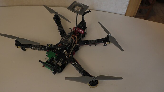
I have built a HolyBro x500 V2 Drone with Pixhawk 6c and M10 GPS. I have added a Nvidia Jetson Orin Nano and an Intel RealSense D435i depth camera to the drone.
Right now I just want to do some simple tests. I put my drone at 2 points in my backyard and recorded the latitude and longitude positions it showed on Mission Planner for both. Then I put the drone at one of those points and created a mission to takeoff from that point, go to the other point, wait for 0.25s and then come back to the original point and then land. I do not use RTL.
I ran this mission 4 times and in all but 1 attempt, the drone went in the wrong direction. I did not change anything between this attempts. The first try, it flew towards the correct waypoint, albeit a little to the right, but it was about to hit something in my backyard so I had to manually stop it. After that, for all other tries, the drone took off and then immediately began going left while the waypoint was straight ahead.
I know that I won’t be able to achieve pin point precision due to my GPS but these last few attempts were not even close to being in the correct direction. The M10 GPS has a 2m precision. The way this drone was moving, it would have ended up 15 meters away from the set waypoint.
What might be the issue?
What are my options to make the drone go to an exact point with a margin of error at most 1.5m? Are there any options besides using RTK?
2m precision on a M10 are pure marketing figures.
In a backyard with trees, fences and walls it will never provide that.
Get a F9P with a helical antenna without any sky obstructions and it will deliver 3m without RTK corrections.
And that USB camera is known for butchering the GPS signal. So remove it or keep it far away fron the gps antenna.
There is no guarantee of 2m accuracy. The position accuracy stated by uBlox is CEP. What is that?
Circular Error Probability
CEP, 50%, 24 hours static, –130 dBm, > 6 SVs for each GNSS system
And
GPS is always in combination with SBAS and QZSS
How far would the camera have to be? Why does it affect the gps signal? that makes no sense.
Additionally, If I do buy the F9P, can I use a NTRIP subscription to use RTK? Also will RTK help me stabilize the drone? Right now when I tell the drone to takeoff, hold for 1s, and then land, the drone moves during the hold time and sometimes lands as far as 1ft or more away from the takeoff spot. Will RTK at least minimize this variation?
That depends on a multitude of factors like cables, plugs, shildings. So you need to test it on your system.
USB 3.0 Uses 1,5Gbps datarate. GPS operates in the 1,4 GHz band-
These are close to each other and causes interference.
It does make full sense once you consider the facts. Additionally multiple users have the same exact problem. And removing the USB camera fixed the issues.
It might not make sense to you but it has to many others.
Im facing similar issue, i have a speedybee F405 V4, with Matek m10q
I was using iNav at first, and i never had any issues with the GPS, with it i was always landing within 1.5m of the target, but after switching over to ardupilot, the GPS accuracy went down, and sometime like by 10m to 15m
I don’t think its the issue of ardupilot, i did crash my drone quite a few times, and i think its possible i have damaged my GPS
Is there any way I could minimize how much it affects the GPS without removing it or moving it further away than it already is? I need it for my project and I already have it at the furthest possible point away from the GPS.
Could you please also answer my other question regarding RTK with F9P and NTRIP subscription? Thank you for your help so far
@dkemxr This is extremely helpful. Thanks!
try sheidling, put the gps over a metal disk
To get accuracy you need a combination of three things:
- a correctly built copter . Built using know and published best practices.
- a good RTK setup with helical antenna and good shilding, good power supply and low latency ntrip corrections.
- a correctly configured and tuned vehicle. Again using know best practices.
Without all three you will not get what you want.
My team got all that working in 2019 already so I know it is possible, but you need to put some work on it.
We did a guide explaining all this and a software that semi automates most configuration steps.
It was 6 years ago, I built a DISCOVERY copter with an APM 2.6 flight controller and a u-Blox LEA-6H GPS receiver. I did the settings according to the recommendations of the ARDUCOPTER documentation, which is now in the archive. However, the accuracy of landing, when performing a flight in automatic mode, was always at the starting point - on a cardboard platform from the package. It is obvious that such accuracy is sufficient, while the old satellite receiver worked without GLONASS.
It’s unbelievable, but I had such a precise fit even after installing the MTK MT3329 receiver.
TBS Discovery test AUTO Nokia Landing 15 07 2018
I’ve had this exact issue with a camera cable running under the GPS. Totally destroyed any hope of getting a fix at all. Wrapped the camera cable in shielding and moved it away from the GPS, no other changes, GPS fix was good. Others here have already explained why it makes sense, so I will only say that it does.
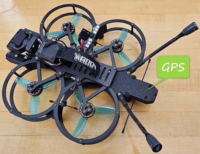
Fully agree with @amilcarlucas on GPS functionality. I have built multiple quads (10", 7" and 3.5") and the location of the GPS unit on the vehicle will make a tremendous difference. On the 10" quads where the GPS is placed on a 100mm mast above all the electronics, antennas and motors, I get a full DGPS with 15+ sat. less than a minute in a new location. On the 3.5" the initial location of the GPS (M9N) was 60mm from the FC, ESC and BEC and It took many minutes to lock a few sats. I redesigned the GPS case, putting it 80mm away (see image) from all the electronics, and now it operates as expected.
