Torque Turn Waypoint

I know right now we’re limited to normal waypoints and spline waypoints in terms of flight planning, would it be worth adding a torque turn waypoint like this for Traditional Heli’s, or has anyone attempted anything like this yet in an auto flight mode?

The main reason why I’m asking, I much prefer straight flightlines so splines are problematic, and I want to minimize overshoot distance. A torque turn would minimize overshoot and help maintain forward speed at the same time.

I’d definitely be willing to help get this type of waypoint developed and flight tested, I have a Trex500 that I’m pretty much only going to use for flight testing and having fun, not flying surveys.

I don’t think I’d trust the autopilot to do that. It’s called an ag turn or on-target turn, and can be either torque or anti-torque depending on the direction of turn. I’ll do it flying manually but you’re dangerously close to LTE in that type of turn. It depends on which way the tail rotor blows as to how it’s executed. You always keep your tail rotor in clean air by kicking the tail up to keep it out of the rotor downwash at the apex. And is why, for instance, clearing turns are done left pedal (with normal CCW rotation full-size).

Ag pilots do it all the time dangerously close to a blow-out and don’t think anything of it. But there are no ag pilots with less than 2,000 hrs PIC time either.

I didn’t think that would be much of an issue being these things can stand on their tails doing tic tocs, but then again they’re not carrying 2lbs plus camera sensor when flying 3D either…LOL

They’re running insane headspeeds when doing that, which also means insane tail rotor rpm. You don’t have as much tail authority at the lower headspeeds UAV heli’s are flown at.

Yeah good point, I’ll just have to make the spline waypoints work I guess.

I’d like to point out that a fair amount of overrun is not a bad thing shooting surveys. I don’t use a camera that shoots controlled by the autopilot based on distance. Because they don’t work all that well with fixed cameras in a helicopter banked over at 45-50 degrees in a turn.

I prefer to use a camera that shoots with a timer on 5 second intervals for 75 feet over terrain surveys. The overrun distance insures that the helicopter is lined up on the next pass with enough distance to get that first shot on the next pass at a point where you don’t miss or have any gaps in the imagery. If you make your turn too tight you could over-fly the camera and miss part of the edge of the Section that you’re shooting, depending on where the camera gets the shots. If it snaps a shot at the apex of the turn and 5 seconds later is already well into the next pass you’ll have a gap.

Remember that on surveys your passes will be spaced based on the FOV and focal length of the camera lens (ground footprint). Which is way wider than a spray boom. So survey turns are always arcs anyway.

It’s really not a big deal to put spline waypoints in a line so the ground track is straight.

On some of these flights like this one that I’ve posted before, the field is odd-shaped. This a flight where I have to get every square foot with RGB for crop insurance. They look for planter skips, uneven stand and I don’t know what all. But you’ll see a brief shot of the tablet screen with the flight plan on it. Being the field is odd-shaped I didn’t fly straight passes on it. I flew the perimeter of it, which was like 4.5 miles on the first round. Then turned the helicopter around and made another pass up thru the middle to get what I missed on the perimeter round. If you watch carefully in the FPV you’ll see the helicopter making a shallow turn on the pass.

It’s just getting every square foot and then the imagery is put together in post to make a mosaic or composite image of the field for the crop insurance adjuster. So it ends up like a satellite shot of the field, except at 100x the detail.

So they’re not all “textbook” survey flights.

I understand, but I fly surveys for Civil Engineering applications mostly, and yes forward lap & side lap are extremely important, and for me having the camera on a timer is not accurate enough, I always trigger based on distance and I post process correct my exterior with an L1 GPS onboard the aircraft using a GPS base, this results in an extremely accurate exterior. I’ve captured tens of thousands of frames this way and its extremely reliable, it just takes the right shutter cable and settings, on most flights I take around 1,350 frames and there’s never any gaps or missed frames.

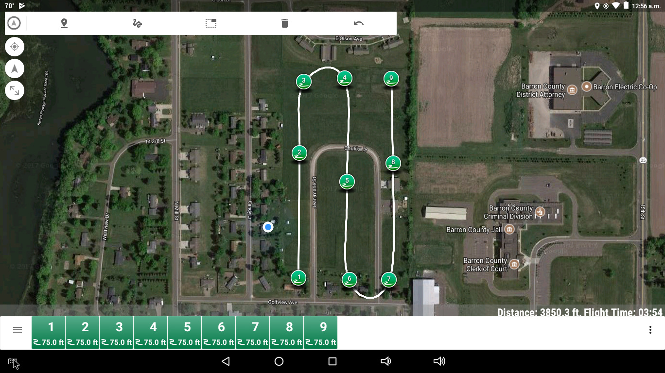
The only thing I don’t like about the spline waypoints is all the curves in flight lines, not sure that I can get them straightened out without a lot of work each time, I absolutely need straight flight lines.

I usually turn “break up starts” off being I don’t care if the camera triggers while turning, I just don’t use those frames, a lot of time if you leave it on, it will miss frames on the ends of the flightlines which is incredibly frustrating.

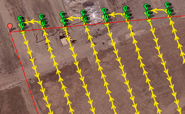
I still want to reduce the overshoots though, being many surveys I do are adjacent to busy highways and residential areas sometimes, and with the current Part 107 rules we’re not allowed to fly over people or moving vehicles, that’s the main reason why I’m interested in minimizing overshoot, this is really the only thing I like about multirotors, because they simply flare to a stop at the end of flightlines, slide over, then fly the next flightline back the other way, all with zero overshoot.

I guess I could always have it fly the same way multirotors fly with normal waypoints, flare to a stop at the end, turn 90, then turn 90 again, then accelerate down the next flight line, I know I would lose efficiency due to the hover/slow turnaround, but flight time will still increase over a multirotor overall.

Ok, after messing around with the flight planning tools, I think I’ve got it now, flightlines are very straight with all spline waypoints, and I’ve only got a small amount of overshoot and lead-in (5 meters). Will have to adjust according to speed, but I think this will work:

It may. But helicopters are usually bigger and heavier than multi’s and it takes power (collective pitch) to decelerate and accelerate mass.

I’ve flown plenty of civil engineering surveys on tacconite and frac sand mines as well using 90 degree camera angle.

Multi-rotors are about the most inefficient, if not THE most inefficient aircraft ever devised by man. The more time they can spend stationary, the better they like it. Helicopters really need to be flown more like a fixed-wing to take advantage of their performance capabilities.

When I whip up a new flight plan 99% of them are done on the 12" tablet with Tower. I just click on the squiggly line, set it to spline and draw on the screen with my finger where I want the heli to fly and it puts in all the waypoints. Then adjust them a bit by moving them around to fine tune it. I can do a constant altitude flight plan on a full section in under five minutes.

I just did a demo one with all spline on land my wife and I own in back of our house to show you how it comes out. You set the amount of overrun by moving the center waypoints back and forth. I set my speed for the flight with channel 6. And the helicopter will fly it smooth as glass. No stopping or hesitating, turning like a robot, sliding over and going again.

I can make those arc turns on the end of the passes just about 90 degree turns by setting another waypoint and sliding them towards the end waypoints, so the mathematical spline comes out as a square corner. But the helicopter will decelerate and slow automatically to make square corners like that because it stays within the acceleration limits you have set.

I’ve never had an issue doing what you want to do using all spline waypoints. It just takes learning how to do it :wink:

Yep, it will definitely work. To tune for it you have to make a sample “test” flight plan and fly at the speed you intend to fly. And tune that WPNAV accel until the helicopter is making the turns correctly. With the WPNAV accel at the default value of 100 it “chops off” the corners at a high cruise speed. I don’t know for sure, but I think the ground station software assumes default accels and default speed of 5 m/s.The ground track can be different depending on how the helicopter is tuned for waypoint flying. If the speed is too high and the G-forces would be too high for the limit you have set, it seems to sort of “average” the waypoints in a turn instead of flying the precise ground track it shows in the software. So the ~90 degree corners you see in the software may end up being an arc anyway, but it will be “chopped off” inside the track shown in the planning software unless you are flying at multirotor speeds.

Ok thanks again Chris, I think I’ll be able to get this to work, and I definitely see it will take several test flights to get everything adjusted for the speeds and overshoot I want.

Cool. Some of us would like to eventually update the wiki on helicopter documentation, and tuning for waypoint flying at higher speeds than multi’s normally fly at would be some useful information for the wiki.

Ok great, I’ll keep careful notes on what I come up with and will get back to you on that, I plan to test with my 500 first, then once I have that working well, will tune my 700 with its normal payload for the same type of surveys I do with fixed wings, without the huge overshoot of course, LOL!