From what I’ve read, seems a bit fuzzy. When creating an auto mission in Mission Planner using terrain, is the terrain data loaded when uploading the mission or through Mavlink on the telemetry link? Hate to lose link and have it come home.
please read
http://ardupilot.org/copter/docs/common-terrain-following.html#common-terrain-following
how it works.
I was reading the newer text referring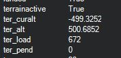 to copter, which didn’t mention if it was loaded, thanks. Set it up, but getting some odd altitude numbers. Altitude of home is 510m, where I’m sitting right now is 500 (just down the road from where I’ll be flying tomorrow). So my ter_alt is 500, makes sense. My ter_curalt is -499, doesn’t make so much sense lol!
did you have gps lock when testing? I asume the answer is no.
so your current alt is 500 - 499, ie 0…ish
That would be it! I had 6 sats and a 3D fix, but near a window indoors. Went outside and the numbers lined up. One last question. I want to use SRTM data and terrain following to allow my unit to follow uneven terrain while scanning with a lidar (AL3 mapping lidar). It’s important I don’t go above 80m or I won’t be mapping anything lol. Given SRTM can be inaccurate, I want to use a scout unit to fly the grid first. For the scout, can I terrain follow with SRTM, but also have a lidar lite telling me if I’m closer than 40m to ground or tree tops without actually using the lidar lite for terrain following? Basically I want to know if the SRTM for that flight is accurate enough. In the area I’m flying, using the lidar lite would be difficult because of the dramatic terrain changes and the number of large trees.