Hi,
I’m new here, could someone help me with the meaning of the different stats in the survey grid window please?
Thanks!!
Hi,
I’m new here, could someone help me with the meaning of the different stats in the survey grid window please?
Thanks!!
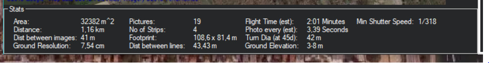
Area: Covered area for the survey
Distance : Total distance to fly for the survey
Distance between images: Distance flown between image takes
Ground resolution : 1 pixel will be this large
Pictures : Pictures to be taken.
No of strips : Picture strips needed to cover the area
Footprint : One picture covers a rectangle this large
Distance between lines : Distance between flight lines (stips)
Flight time : estimated flight time for the suvey
Photo every : Pictures going to be taken every xxx seconds
Turn diameter : turning at the end of lines will be this large (diameter)
Ground elevation : ground height min max in the covered area
Min Shutter speed: Minimum shutter speed needed to avoid motion blurring on the pictures
Thanks!! 
@Eosbandi Do you also know what’s the difference in selecting the “camera top facing forward” or not?
It’s about how the camera is placed, top of the picture is the same way as the nose or rotated by 90 deg.
Ok, thanks! Is there a way to define the angle in which the camera is orientated through the mission planner?
Sorry, I’m asking a lot of questions…
If you mean to define camera orientation for mapping, the only way to do it is front facing top or 90deg rotated. (There is no use for other orientations anyway).
If you mean to set the orientation of the craft or gimbal, there are number of posibilities.
If your gimbal has PAN control de a DO_MOUNT_CONTROL can change pan angle during a mission.
Or you can change the YAW of the craft with a CONDITION_YAW command as well.
Yes, I mean the second case, that the camera is going to take pictures with a desired pitch angle. Therefore, I assume I must control the pitch of the gimbal to do so.
I guess you want to create 2.5D rendering which need photos from multiple angles. In this case yes, you need a gimbal which is controlled by the autopilot, and must add a DO_MOUNT_CONTROL to your mission manually.
Not at all, it’s just that the dron is going to follow a grid and instead of having the camera pointing downwards, it will be pointing forwards (the same direction the drone is taking or not) with a given anlge respect the ground. I thing the DO_MOUNT_CONTROL will work for me anyway. Thanks!
Hi,
For a camera facing downwards, as the vehicle moves it will pitch by some angle. Will that not affect the photo orientation? Is there a way to compensate for this ?
Regards,
Raj Patel
you need a camera gimbal that will keep the camera orientated down.