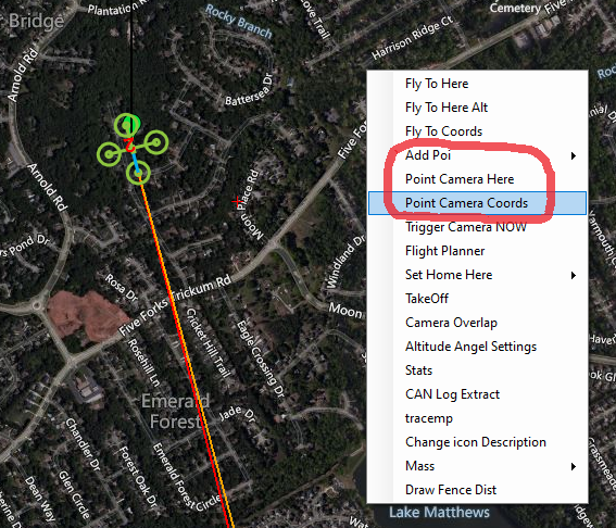
I’m trying to identify the parameters that hold the lat/long/elev for POI (point of interest) and Point Camera Here settings.
Can someone please help me identify these parameters?
Thank you!

I’m trying to identify the parameters that hold the lat/long/elev for POI (point of interest) and Point Camera Here settings.
Can someone please help me identify these parameters?
Thank you!

It’s in the Waypoint file.
Excellent - thanks Dave!
I can’t seem to find any docs that describe this file - where it resides, how to view or edit it - or when one should or should not do so.
Honest - I put google to work trying to find out. Can you point me to some docs?
It’s saved on the Autopilot but if you use the “Save File” button it will save a text file that you can view with any text editor. In it you will see a bunch of columns. The 4th column is the mission command column and the value corresponds with the Mavlink command. In this case POI is 201.
Excellent again - Thank you.
I think I need some clarification between POI and ROI.
When I create a ROI waypoint, it puts the line in the file with the “201” identifier.
But if I do the left-click on the map and create a POI - nothing gets added to the file.
Plus - doing the Add POI function allows saving and loading POI’s from a .txt file.
The POI’s get labeled - but I don’t know how to do a command or function that addresses them.
My guess is that it has to do with pointing the gimbal. When you do the right-click and “point camera here” - my guess it does both the creation of a POI, and and action of commanding the gimbal to point to it. (that’s how things work on my copter on the work bench)
So I’m guessing that any POI’s that are created are referenced by other commands - just not sure which ones - or how to do it.
Sorry this is kind of an onerous question - if there’s a place I can read up on it, I’d be happy to save you the trouble of explaining it to me.
Dave -
I’ve been digging into what a POI really is.
It appears from what I’ve tried that a POI is a visual reference marker in Mission Planner - it simply marks a point on a map. It’s persistent - it stays even if connecting to other vehicles - it’s not stored on the vehicle. POI’s however can be saved to and loaded from a file.
It would appear that it functions only as a visual reference - there’s no way I could find that allows you to enter a POI’s coordinates into a mission line. And POI’s don’t appear to be saved in a waypoint file.
This WP file has a POI after WP1. Command 201 with a coordinate and an elevation. There is another one after WP4 that set’s it back to default (zeroes in those columns). These are stored on the Autopilot when the Mission Write is done.
Mission3.zip (312 Bytes)
I see the issue and it relates to your other question. It’s not a POI command in the WP file it’s an ROI command. So I think you are correct about the POI and I was confusing the 2.
There is a POI.txt file saved in the root folder where the logs are stored. It has the POI names and their coordinates.