NMEA water speed sensor is supported as a type 13 airspeed sensor
Nema out from the flight controller is serial mode 20.
NMEA water speed sensor is supported as a type 13 airspeed sensor
Nema out from the flight controller is serial mode 20.
I meant to add 2 functions. The first is NMEA input support (currently GPS only) for Ardupilot for multiple devices at once. The second follows from the first, NMEA output for Mission planner (now there is only GPS)
We actually support several of NMEA input devices, although as you say we cannot share a single serial port.
Off the top of my head:
I think the problem is they have all been added a piece at a time over the years, there has never been a unified NEMA input.
GPS
Rangefinder/depth sounder
Temprature
Boat speed
Wind speed and direction
AIS
currently connecting all that is essentially impossible as it would take more serial ports than are available.I think this is also the cause of some issues when i try and use the nmea gps in my ais receiver, as it doesnt know what to do with the AIS messanges
The easiest solution which I choose for nmea out is a Lua script to output on a specific serial port a specific nmea string for my needs.
This port can be connected to a radio, or a companion and then captures and retransmitted via a digital link back to GCS.
So you might make a workaround for your needs using LUA, ie combine values from vanes, depth etc to a single nmea.
Last but not least, you can import almost anything in mission planner base map (not only rasters) with custom wms
can you share your script?
Then why do we need an Ardupilot? 
I agree that there is no single standard for the equipment of rover and aircraft. Because of this, you have to use a bunch of different i2c, CAN, ADC SPI, and the COM port
There are communication standards for ships (old NMEA 0183, newer NMEA2000 and SignalK)
For a boat, it is easier to assemble all the devices into one network (via NMEA) and transmit via mobile, wi-fi or satellite (what is needed).
Yes, there are for some devices, but as @geofrancis said, one input (com port) is not standardized for all NMEA devices.
The ASV group at the Center for Coastal and Ocean Mapping, Univ of New Hampshire, has developed quite a few tools you all might be interested in. Larger ocean going diesel boats are typically used but the system has been installed as a backseat driver for smaller ArduPilot boats as well. It is opensource, would be great if MissionPlanner could adopt some of the features.
It is an EU funded research program, so I will upload all related data as soon as the relevant article gets released. So far the most difficult thing I stamped by, is the humongous refresh rates that most multi beam sonars demand (~200hz), meaning one should play with schedule loop rates, along with the nmea translation, hive equation and LUA…
At the moment iam gathering data to find possible culprits and make a separate post.
is there any way of getting the nautical charts into mission planner? even in a 2d jpg format for planning. can they be exported in georeferenced images from openCPN?
I was testing this again recently and noticed you dont need the virtual serial, you can just set it up as a tcp client and connect to mission planner over the network.
Well, as soon as I get back from a business trip, I’ll try.
I have been trying to work out how to get a mission from mission planner into openCPN so i can adjust it. my only solution so far is to run the waypoint mission with the simulator in mission planner at high speed to create a track in OpenCPN that I can then use to adjust the mission in mission planner. its not ideal, but unless someone figures out how to get marine charts into mission planner it’s the only solution so far.
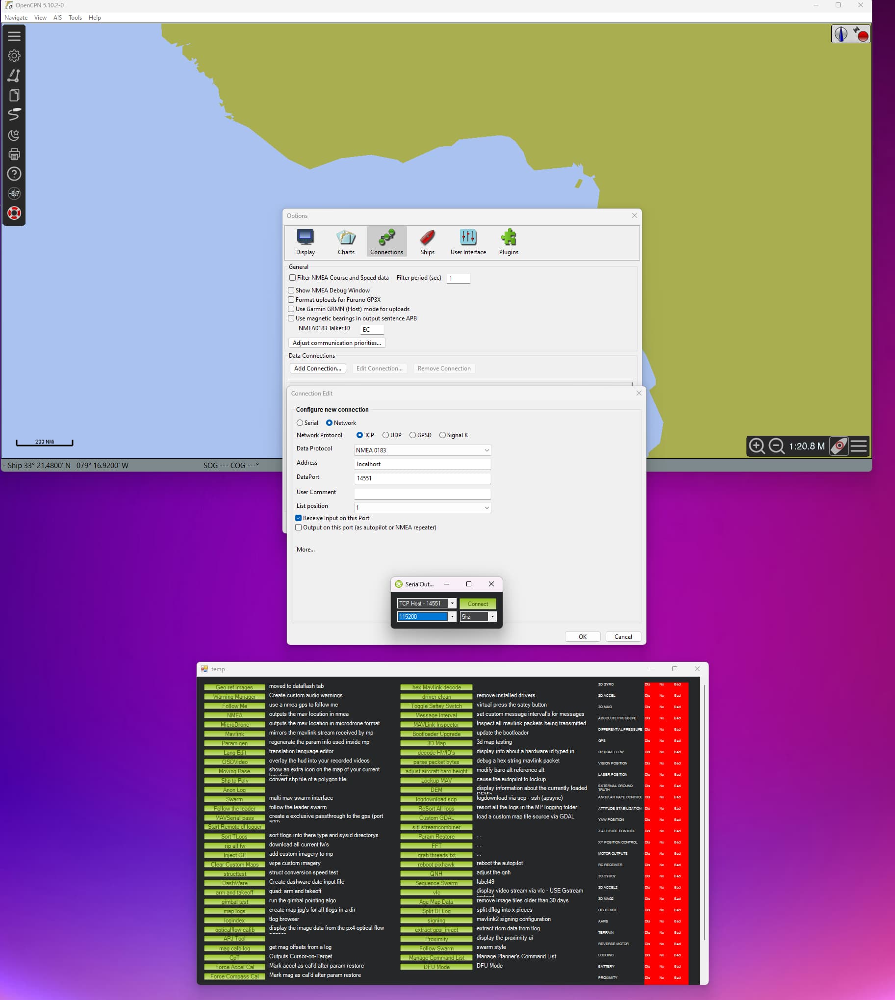
Hello, how can I connect MP to the OPENCPN via TCP ?
If there’s any interest I could build a module that renders nautical charts as a raster tile server – so you could plug in the service as a Custom tile URL and it would render charts that you’d load. The charts would be hosted as a separate program, though.
How did you link opencpn and mission planner together?
In mission planner then press CTRL+F to open the menu, then click the NMEA button to bring out the serial out menu, then from the drop-down select “TCP HOST” click connect.
Open openCPM and go to options then connections and click add connection, select network>TCP and set data port to 14551 then connect.
Hi!
Thanks for the info. appreciated ![]()
Is there any sonar chart available or OpenCPN, I need something like Garming Map Navionics. That map is very much detailed.