Good morning - and my apologies if this has been asked before.
Is there any documentation on how to use Mission Planner ? I cannot seem to work out how to modify a mission once I have saved it, or how to bring in a map from another source ?
Currently trying to work out how to do a bathymetric survey with a boat in Africa and Google maps doesnt show the correct images for my location.
…essentially a very easy and intuitive way,…just click on the various points you want the vehicle (boat) to go to (on the map) and then change each point as required (options in drop-down list in every line (called waypoint).
You can also move the points around with the mouse to suit. When you are happy with your “mission” save to your controller and if you wish you can also save it in a file on your computer. In that way you can re-load various missions as required. If you need to change something you have to download from your controller or load from file, edit it and then save or upload to controller.
…have fun.
I was hoping that once I had designed my survey I could change my line spacing and spacing inline for the entire flight instead of moving each point around.
Well, haven’t really tried to create such a mission.
I believe best is to just set one marker at start of run (line) and another one at end without any waypoints (markers) in between.
The other, more advanced option is to right click on planning screen. This will open a whole list of additional functions. In there you’ll find specific options to create plans for survey missions with custom spacing and practically everything you could want.
…just had a quick look:
Just draw a polygon over the area you want to have a grid over (using the polygon function) and then click on Auto WP-Grid.
Then a new window will open showing you the grid and all spacing. You can then adjust in the settings as required.
That’s 100% correct Karl - draw the polygon, do the Auto-WP grid and a new window opens with a load of settings you can adjust. Perfect.
However, once you click accept I can find no way to go back to that window. So if I do a mission and then realize my line spacing is out I cannot adjust it easily.
I need to play a bit more with it. Many thanks for your detailed response !
I am aware of this - but that isnt the problem. Maybe I am not explaining it well !
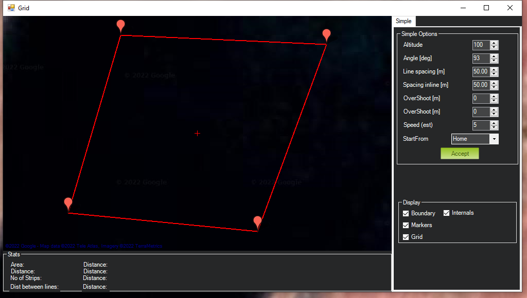
When I do a mission I create a polygon, then right click, choose Auto Waypoint, Simple Grid. This opens up a seperate window with Altitude / Angle / Line spacing etc as below.
Once I click accept, I can run my flight, but if I want to change any of these options I can find no way to open that window again ?
I hope the image uploads and makes it clearer to understand…
I understand the problem at hand. There is no native way to do what you’re asking. But if you save the polygon, you can clear the previous mission, reload the polygon, and repopulate with the parameters you desire.