I’m not an RC guy; I fly a Super Decathlon. A couple of us “occupied acro airplane” pilots are adapting Flight Coach for use as a recorder, but I can’t get my HW configured to record.
I have a Matek H743-WING connected via the CAN bus to an M8Q-CAN GPS. I’m using it as a recorder for Flight Coach, not for a model. I purchased the H743 in March, 2021. It was recording in the Spring of 2021 and I wanted to take advantage of recent progress in the Flight Coach adaptation.
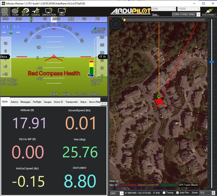
I re-flashed Ardupilot to the H743-WING it last week with the version of Ardupilot Plane available on Mission Planner. MP displays the dreaded “GPS: No GPS” message and the EVK annunciation displays red. A “Bad Compass Health” message alternates with a "(Safety): message.
The H743 calibrates correctly for attitude, but I don’t believe the M8Q ever calibrated correctly. It does not display a correct mag heading and the heading seems to continuously drift.
The M8Q green LED blinks at 1 Hz, implying good position and the blue LED blinks slowly, implying a good interface with the H743.
I have uploaded the Flight Coach parameters I’m using below. I probably have incorrect settings after trial-and-mostly-error attempts to apply suggestions from the wiki and other places.
Did I inadvertently flash firmware for V2 or V3 of the H743 which is not compatible for my 2021 version of the H743, such that I need different params?
If the latest version of Ardupilot isn’t going to work, is an older version of Ardupilot available for my H743 version?
How can I confirm my H743 version?
What should I be examining in Mission Planner to troubleshoot?
Congratulations that the GPS is working. The most important thing is that LOG_DISARMED is 1. This means that the data (including the GPS data) is logged all the time. I don’t know Flight Coach, but I just saw that it is based on arduplane. So maybe the GPS log is enough to look at the flown trajectory later.
Two BIN files were recorded. The second one plays in Mission Planner and in Flight Coach. The airplane icon continuously rotates about the yaw axis in both visualizations. I used MP to convert the BIN files to LOG files for download. MP reports they are downloaded, but I can’t find them. There is no Mission Planner\log directory on my desktop.
I’ve watched my drive in both MP and in Flight Coach. The trajectory data is OK (although the altitude data is suspect), but the airplane icon continuously rotates about the yaw axis. I found a plethora of log files.
If those were done, and compass calibration was successful, and it’s still off by 90 degrees, then you might want to file a bug and include a log file.
Yes; just to make certain, I re-calibrated the board IMUs and re-calibrated the compass. Mission Planner showed an orientation aligned with a local terrain feature correctly, but the mag heading was off by an amount very close to the variation (aka: declination) for my location. As I moved the HW around, the compass heading would vary erratically.