Hey all,
I would need some help from you specialists, please.
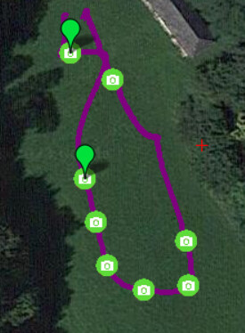
As you can see on the attached pictures, in the logfile are the positions of the trigger points. You can also see a screenshot from the EXIF. It looks, that there is some GPS informations forwarding to camera but totally wrong informations. Longitude, Latitude and Altitude is “0;0;0”. If I move the mouse over the trigger points, I can see the altitude but no position informations.
I urgently need to have the gps coordinates in the EXIF. As Gimbal was the Gremsy F attached.
Any suggestions what the reason could be?
Thanks a lot for your help guys!


Please update to ArduCopter 4.4.1 and retest. If that does not work, update to ArduCopter 4.5.0-DEV and retest.
Is it save to update without any strange changes in settings to crash the copter?
Yes, very safe. No need to change the parameters, the firmware will automatically update the parameters if necessary
Which camera model? How is the camera connected to the autopilot?
Gremsy F Gimbal, Flir Duo Pro R camera. I remember it was working earlier. Could it be a Gremsy issue? But if the positions are also not visible in the “Geo Ref Images” - Option from Mission Planner, looks like not Gremsy, or?
Could it be mavlink related? Camera triggering was done by distance and flight planning was done by UGCS software. I was able to trigger the camera via remote (QGroundControl on Herelink) and also via UGCS software directly.

