I have been playing around with MP/Pixhawk for a while (3DR Iris+ and Aero). During planning (setting waypoints) you may use the different Altitude settings Relative, Absolute and Terrain. During flight or simulation the altimeter always starts with 0ft (at home point) independant on which setting (e.g. absolute) I have selected during the planning phase. In manned aviation this is called QFE reference setting.
Does anyone know if there is a plan to introduce an adjustable setting called QNH i Mission Planner?
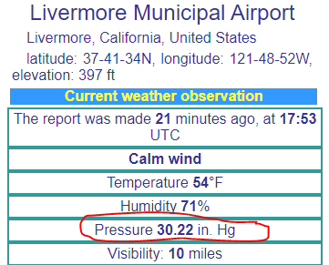
QNH is the barometric pressure (e.g. 1020 hPa) at a specific geographic point at a specific point in time (e.g. NOW). The advantage is that this feature will always give the right altitude (according to the international standard atmosphere, ISA) at the altimeter all the time, given that the QNH is correct set.
It is a safety issue as well, because you may report the correct altitude (based on the AMSL reference) to other (manned) aircrafts. Of course this feature should also be a preconditionary function in the Pixhawk to be able to adjust the QNH reference and load the right altitude data in context with the waypoints.
QNH is also a mandatory setting for all aircrafts taking off or landing at airports worldwide. Hence I am a bit surprised that this is not a feature yet. Has anyone (programmers) discussed this issue?
I fly UAS in support of wildfire and other emergency response operations. Often those operations involve flying in the same airspace as manned aircraft. All of our pilots are also experienced manned aircraft pilots so in our eyes the only thing that has changed is where the pilot is sitting while the aircraft is flying. With a few caveats…
I agree that a barometric altimeter setting is a much needed addition especially when operating in the same airspace with manned aircraft. Every manned aircraft is required to have a barometric altimeter that can be adjusted to compensate for elevation offsets resulting from pressure changes. A barometric altimeter is a primary flight instrument that is used for manned aircraft to hold their altitude assigned by air traffic control. It is checked before each take off (it must be within 70 feet of field elevation). It is also used to put all aircraft “on the same page” when it comes to airspace deconfliction based on altitude separation in an emergency environment.
Since manned aircraft do not use GPS altimeters, their altitude can easily vary several hundreds of feet from the GPS altitude depending on the altimeter setting. In order to safely operate in the same airspace it is imperative that the UAS is able to be programed to fly a calibrated barometric altitude.
In other words, if, before launch, I call a manned aircraft circling overhead and ask them what their altimeter setting is I should be able to program it into the UAS. That way, when we agree to maintain 500-feet of vertical separation we actually have 500-feet between us.
Although very few people would probably use this feature up front, I truly believe is will be essential to the long term strategy of integrating manned and unmanned aircraft into the same airspace. The barometric altimeter has been around since 1928 and I suspect it will be around for a long time to come.
As @menetaero stated, inHg is engraved into aviators’ minds and we would like to avoid any miss interpretation during multilayer communication between agencies during national emergencies such as forest fires, etc.
As an aviator, we get this information from departing and destination airport to compensate for our altimeter.
Hi Michael,
is this function in other words called as Barometric remote sub-scaling?
please correct. me if wrong. and as mentioned did other standards are also incoprated.
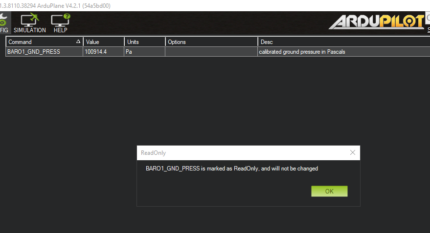
We are meant to adjust BARO_FIELD_ELV and BARO_GND_TEMP
I assume setting these accurately will feed into a more accurate baro-derived altitude. EDIT: yes, in the code I can see where those two values are used to calculate a corrected pressure. Without those being set manually or by a GCS, there is a best-effort guess.
The BAROx_GND_PRESS value is read only and cannot be manually changed.
Calcs should be good up to 11,000 m amsl , above that you are on your own