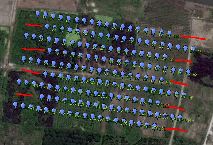
When flying recently, I used the Survey (Gird) tool to chart a 8-line task. When the flight was over, I read 171 location information from the logbook (my Sony camera just took 171 photos), but each line lacks about 3 photos. It is weird that anyone knows this question?
Do you have the mission saved? It would help to be able to see the exact waypoints it created. A .tlog from the flight would work too.
https://1drv.ms/u/s!AnzLCgQpaNDgabPYuvPTtKWo-7s
This is my route file and t-log file in Onedrive, please help us to see, thank you!
Have you tried GEO tagging the images with DFlog? Sometimes you wont get the icon due to degraded telemetry link, but the data is in the dflog
I don’t see anything inherently wrong with the mission. Because the copter appears to be dropping the last few photos on each transect, I can think of a few possibilities:
-
The GPS data of each photo is wrong
It could be that you have all the correct photos, but somehow the GPS locations got shifted. Check some of the photos to make sure that their location looks correct. I’m not sure where this GPS data comes from, but some programs will modify the locations based on the tilt angle of the camera or some other factors. If you’re using a program which has this option, make sure you have the tilt angle set right. -
The camera’s photo buffer is filling up
It is triggering the camera with a DO_SET_CAMERA_TRIGG_DIST of 15.6 meters, and your mission speed is 8 m/s. This means you’re taking a photo about once every 2 seconds. Digital cameras will have a limit on how many photos they can take in rapid succession, as each photo is saved in a buffer before being processed and written to disk. Maybe experiment with your camera and see how many shots you can get rapidly before you have to wait.
I’m not sure what might have caused this, but you should be able to work around it by unsetting the “Break up start points” checkbox in the survey grid options. This will make the copter continue taking photos as it turns the corners, but at least it should capture the whole row.
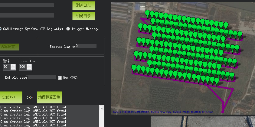
DFlog is that you said inside the pixhawk log files? The map I posted in the forum is the log inside the positioning data, not telemetry log. Thank you for your answer!
I haven’t used the it myself, but Mission Planner has a built-in image georeference function. I think this is what he is talking about.
Press Ctrl+F in Mission Planner. In the window that appears, the first button is Geo Reference Photos. With this feature, you can point Mission Planner to the folder containing your folders and to the DataFlash log of the flight (download it with Mission Planner or get it off the Pixhawk’s SD card). It will use the drone’s GPS data and camera shutter commands to edit the GPS metadata in the photos. I think so, anyways.
Thank you for your patience!
As you said, I will check if the photos and locations correspond. I used “Geo ref images” to get the picture of the shooting location, so the feeling should not go wrong.
My camera should be able to meet 2 seconds a photo shoot.
Today I will remove the “Break up start points” check box and try again. Thank you!