hello Ryan
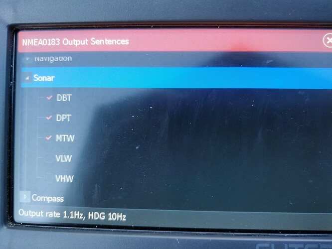
The Lowrance has a whole bunch of different settings to choose which NMEA sentences exactly you’d want to be sent. most interesting are the GPS GPGGA and GPRMC sentences, allthough i’d like the lowrance to use these provided by ardurover.
than there are a bunch of “navigation” sentences which i’d say are not usefull for us. last but not least there are sentences like “DPT” for depth, HDG from the compass (although this will also be provided by ardurover) and also “DBT” and “MTW”(water Temperature) from the sonar (DBT= Depth below Transducer not sure what exactly the difference is between DPT and DBT). if you like i can give you a full list of the about 30 or so different possible sentences. each one of can be enabled/disabled on their own.
this is what i’m receiving at the moment from my lowrance. (by the way, any Lowrance with NMEA capability should be able to send and receive NMEA 0183 AFAIK)
i dumpted my transducer into a bucket of water, hence why i’m not getting an actual depth reading. the sentence is there though. same for hdg, since the boat is not moving.
$SDHDG,,,,,*70<\r><\n>
$SDHDG,,,,,*70<\r><\n>
$GPRMC,165150,A,3232.6402,N,00391.7299,E,0.4,245.3,863322,2.8,E,A*17<\r><\n>
$SDHDG,,,,,*70<\r><\n>
$GPRMC,165150,A,3232.6402,N,00391.7299,E,0.4,245.3,863322,2.8,E,A*1B<\r><\n>
$SDHDG,,,,,*70<\r><\n>
$GPVTG,166.4,T,163.6,M,0.5,N,0.9,K,A*28<\r><\n>
$GPVTG,0.0,T,357.2,M,0.0,N,0.0,K,A*20<\r><\n>
$GPVTG,180.8,T,178.0,M,0.2,N,0.4,K,A*2A<\r><\n>
$SDMTW,26.5,C*05<\r><\n>
$SDHDG,,,,,*70<\r><\n>
$SDDBT,,,,,,*45<\r><\n>
$GPGGA,165213,3232.6402,N,00391.7299,E,1,12,0.70,112,M,47.9,M,,*6D<\r><\n>
$SDDPT,,,*7B<\r><\n>
$SDMTW,26.5,C*05<\r><\n>
$SDHDG,,,,,*70<\r><\n>
$GPGLL,3232.6402,N,00391.7299,E,165221,A,A*40<\r><\n>
$SDHDG,,,,,*70<\r><\n>
$SDHDG,,,,,*70<\r><\n>
$GPRMC,165150,A,3232.6402,N,00391.7299,E,0.4,245.3,863322,2.8,E,A*1B<\r><\n>
$SDDPT,,,*7B<\r><\n>
$SDMTW,26.5,C*05<\r><\n>
$SDHDG,,,,,*70<\r><\n>
i’d like to try and insert gps data into the lowrance. but somehow i can’t get gps nmea sentences to come out of my pixhawk. (Edit: I managed to get this to work. I’m trying to feed the position data into lowrance now) it might be due to my gps reverting back to ublox everytime i restart the pixhawk, since the radiolink gps does not save its settings.
that also means that i still dont know if the connection really is bidirectional.
by the way, should i / we move this discussion over to here? seems to fit better. Lowrance NMEA 0183 to Cube Orange - #3 by geofrancis
cheers.
