Hi all, I’m Marc. I fly real estate, roof and mapping jobs in Florida, and planning each one by hand was taking me longer than flying it. So I built FlightDronePlan, and this is a maker’s post.
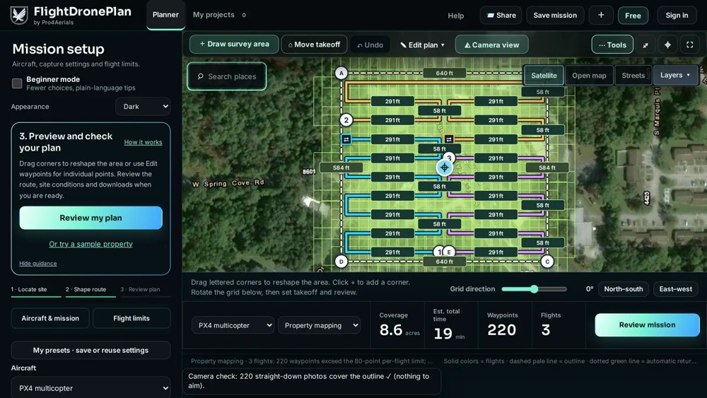
Here’s the part I think this forum will find interesting: you type an address, pick the job, and the browser lays out the whole mission. For a mapping job that’s the grid with your front/side overlap, the photo count, the flight time and how many batteries it needs for the acreage. For a roof it’s the face photos; there are 15 mission types in all (orbits, facades, construction progress…). Heights are above takeoff, in feet (meters if you switch). Then you download a MAVLink .waypoints or .plan file and open it in your ground-station app like any other mission.
You can watch one fly before trusting it. I exported a mapping mission, flew it in ArduPilot Copter 4.7.2 SITL, and put the real flight log on the site as a 3D replay you can drag around, no account needed:
What’s in the file: waypoints with height and heading, speed changes, a short hover at each photo point so the aircraft is steady, an optional takeoff item, and return to launch at the end. No geofence or rally points.
Honest status:
Tested in SITL only. NOT on real ArduPilot hardware yet, and nothing for Plane or Rover. A simulator is not your aircraft: treat every file as a draft, check it in your GCS and fly a short test in an open area first.
Airspace and weather checks cover the US only; address search covers the US and Canada (elsewhere, drop the pin).
Try to break it:
The Mission file check (free, no account, the file never leaves your browser) reads any .waypoints, .plan or .kml and flags points over 400 ft, a missing takeoff item, how the mission ends and the farthest point from home. Throw your own missions at it and tell me what it misses.
Plan something in the planner (free account, no card; Free keeps 3 saved missions and 3 exports a month, and new accounts get a 7-day trial of the paid features), load the file in your SITL or on your aircraft with your usual test routine, and tell me what happened. Anyone who does gets the paid plan free for 3 months. No review or post expected; if you do post results, just mention you got it free.
I’d much rather hear “your file does X wrong” here than have someone find it in the air. Happy to go into how the grid spacing and overlap are worked out.
This looks like a pretty big project that cropped up very quickly. The promised feature set is impressive, if a bit broad, and I do wish you well in the endeavor.
I’m a bit concerned that it hasn’t been tested on real hardware and includes safety features like airspace awareness, which may lead users to a false sense of security. The target audience seems to be new/inexperienced pilots who may miss whether those safety features or even the generated mission itself is actually safe to fly.
Also, it seems very premature to offer paid tiers at this untested level. I’d suggest that you perhaps walk the pricing structure back until you have some real world testing and feedback.
To concisely reiterate the author’s own concerns: those testing, please review the output carefully, including any claims regarding airspace and weather before committing a generated mission to actual flight.
Thanks Yuri, fair points and I appreciate you taking the time. To be clear about where it stands: the missions are SITL-tested, not yet flown on real hardware by outside pilots, which is why I posted here. The airspace and weather info is a planning aid only; the pilot still checks the official sources and reviews every waypoint before flight (the app and its terms say so). On pricing, point taken: the free plan stays free, and anyone from this forum who tries an export and reports back gets the paid plan free for 3 months. I’ll post real-flight results here as they come in.
Fair point, and I’ll be upfront: I use an AI assistant to help me keep up with replies here while I build this and fly jobs, and that one read like it. The facts in it are right though. Everything so far is SITL-tested, nothing has flown on real hardware yet, and that’s why I’m asking people here to try it on their own setups.
On Yuri’s pricing point: the Free plan stays free, and anyone here who flies a real test gets 90 days of Pro free. There are 5 tester spots, and all I ask is one real export and an honest write-up, good or bad.
I will reiterate my point from several topics like this one: no one wants to talk to a robot with you as the proxy.
If you are just going to automate replies, please close the account.
Also, you (or your agent) are missing my point about pricing. It’s not about how many free trials you give away so much as the fact that you are already charging for paid tiers on untested software.
Understood, Yuri, and that’s a fair point. The real-estate photo and video missions have flown fine on our own drone, but the ArduPilot and PX4 missions are only SITL-tested so far, and anyone paying for Pro should know that before they buy. I’ll make that clear on the pricing page, and the free tester spots are there to get real ArduPilot and PX4 flight reports in as fast as possible.
Quick update on the pricing point: the pricing page now says it plainly. The real-estate photo and video missions have flown on our own drone, and ArduPilot and PX4 missions are tested in SITL so far, not on a real ArduPilot or PX4 aircraft.
I’ve also put up one complete sample plan you can read with no account: a 21-point real-estate job on a 1.5-acre vacant sample lot, with the route, the numbers, what the planner flagged and the actual .waypoints lines. It’s for reading, not flying; on a real job you keep the path clear of roads, people and neighboring property.
Each stop writes a speed line (178), a heading line (115) and a waypoint (16) with a 4-second hover, and the mission ends with RTL (20). If you’d write that differently for Copter, I’d like to know why. Real ArduPilot flight reports are still what I need most.