TF Mini-S Range Finder question

I am just stepping in the Lidar space with Arducopter.

I followed the directions to get my TFmini-s installed and operating.

The question I have is the way this data is displayed in Mission Planner

image

It seems that Rangefinder1 is in centimeters however sonarrange is in meters. Is that correct?

In the directions its not clear that there are two different measuring units being used.

https://ardupilot.org/copter/docs/common-benewake-tfmini-lidar.html

Just want to make sure that I am not going crazy lol

Looks like a bug to me… please check on the log what values are stored

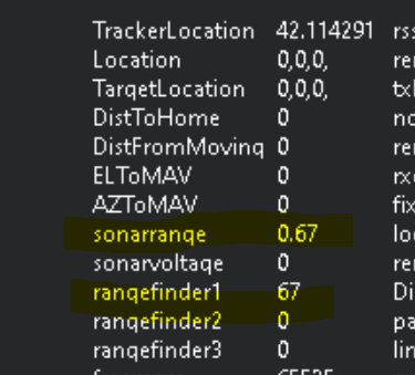
Do you mean the way its represented in MP? The rangefinder1# is right on. The sonarrange seems to be offset by 100.

I did some quick measurements and tested against a wall 4 1/2 meters away. The rangefinder said the wall was 450 away and the sonarrange was 4.5 away. Both are correct if the units are CM and M.

I will take a flight tomorrow and get some real numbers. It raining currently

Ok
I will check on my side as well, because I never really looked at Mission Planner rangefinder numbers on the HUD , just on the logs and on the proximity “radar”

Thanks, looking forward to what you find out. I mean I looked at the code for precision landing and such. They all use the rangefinder data, not the sonar data. So that might be a mission planner thing.

In the logs, what group is the data in?

It is in rngfnd or prx if you set them as proximity sensors

This is my first one, I have it pointed straight down for range finding. And have it configured for a straight down orientation