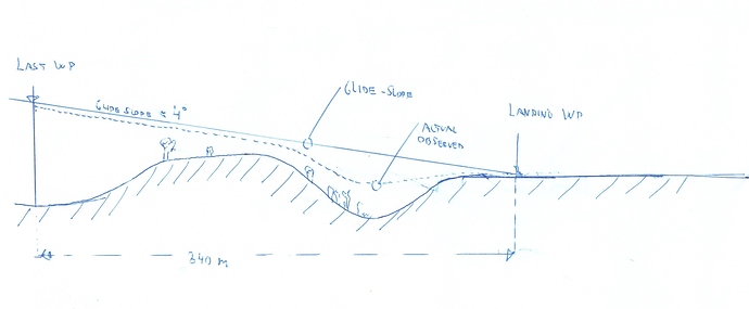
We are atm testing a UAV to do autolanding.
Key specifications:
-
PX4 with Firmware ArduPlane 3.7.1 -
Mission Planner Version 1.3.44 build 1.1.6240.1150 -
Fixed wing UAV, 3.5 meter in wingspan, gross weight ~10Kg
We have atm done about 20 landings with inconsistent results.
Landing strip is 145 meter + 20 meter runoff with sand
We have a hilly entry on the glideslope (refer to enclosed picture)
Auto-landing seems to track the ground (bouncing down and up again about 20 meter from the start of the runway)
Glideslope is about 4 degrees, length of glideslope is about 340 meter
MSL level (from the mission planner) say the last WP and landing WP is at the same MSL
We found the real MSL at the landing WP to be 2 meter higher at the last WP.
Questions:
I. When does the laser range finder “LRF” (using SF11/C) engage/takes over?
a) Just before the flare, or at a given distance front the landing WP?
b) Does the LRF make the UAV try track the ground level, or just accept the glideslope with barometric data and only engage at the flare?
c) Or something else?
II. What is the definition of the landing WP?
a) Is the projected intersection of the glide slope crossing the ground
b) Or the flare point (so the actual landing touch down will be later)?
c) Or is the intended touchdown point after the flare
III. On the OSD we do observe a message “RANGE FINDER ENGAGED”, it does vary in altitude and where at the glideslope it engage, what triggers this event?
IV. Does the Pixhawk use terrain following and verify height also during the glideslope?
Or does the landing mode overrules this parameters assuming it must follow the glideslope
We are not looking for the parameters to apply at this time, we’re only trying to understand the intended behavior during autolanding as the ArduPlane manual differs quite some in the terminologies.
