Hi, I am using a drone that will be loitering in a place where GPS is unavailable. What is the maximum altitude that I can use a px4flow or another optical flow sensor to replace GPS? Would cutting out giant squares or some sort of pattern below the drone help increase it’s max altitude?
Hello,
With the correct lens type and adjustments you could go up to 100 Meters if the ground texture is rich enough to allow for good velocity estimation.
Thanks for the quick response. I’m looking into precision loiter with IR lock now. On the wiki it says the maximum detection range for the beacon is 15 Meters. Would you happen to know of any IR lock beacons that would be detectable at a much larger altitude?
@LukasMarkussen
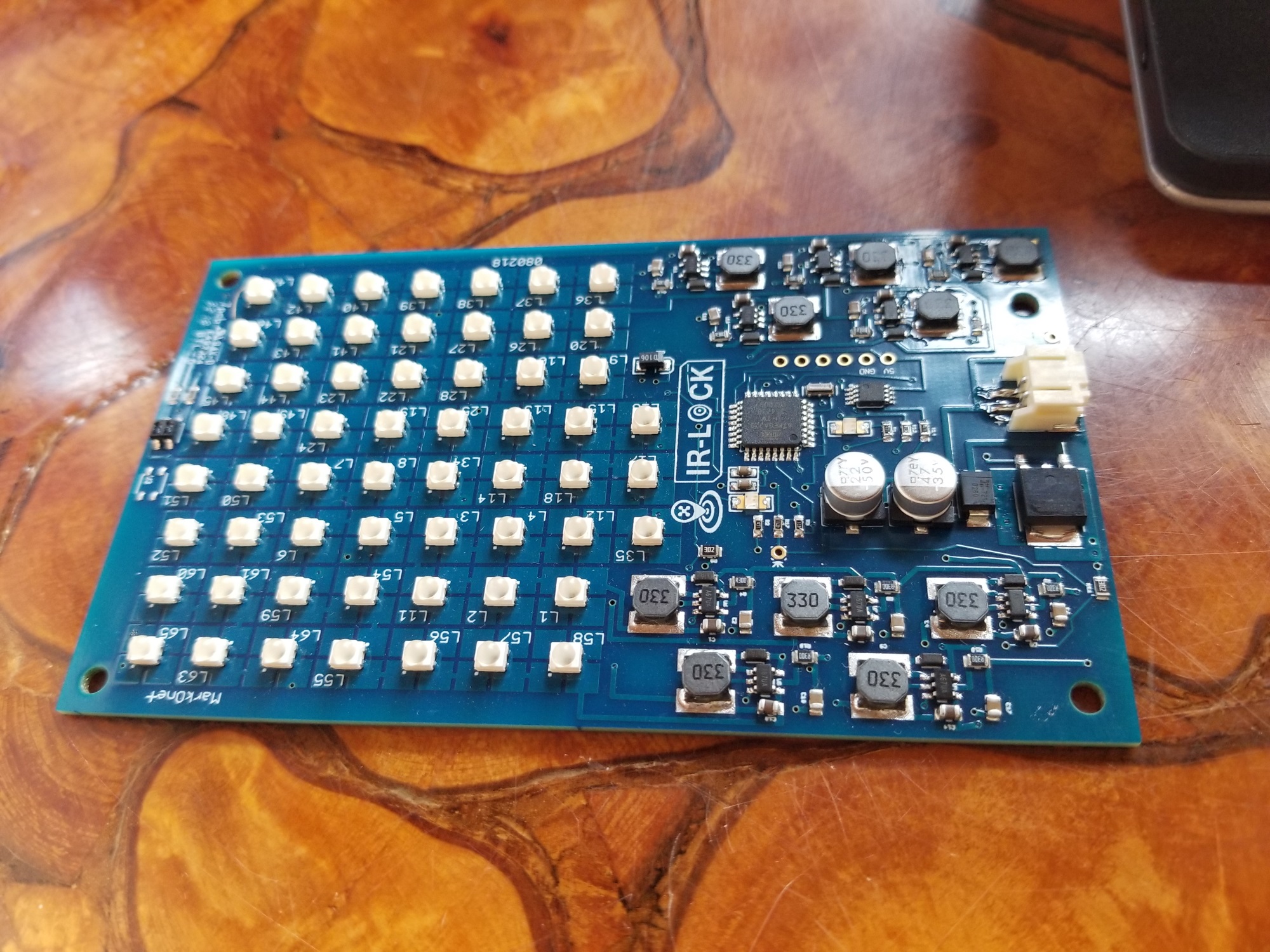
The detection range of IR-LOCK/MarkOne with the default lens and beacon is ~15+ meters.
The detection range can be increased by (1) choosing a different lens and/or (2) using a larger MarkOne Beacon. However, there are some more details to consider.
(1) If you select a lens with a more narrow FOV, then the detection range will increase. However, the FOV decreases. And you will need to modify the lens model.
(2) We develop and sell larger MarkOne beacons for commercial drone projects. This typically requires a minimum order of ~$2,500.
Also, with regards to Precision Loiter, the loiter accuracy will tend to decrease as the altitude increases. This is not an issue with Precision Landing, because the accuracy improves as the copter approaches the target on the ground (and the high-altitude accuracy is not a major concern).
I have a related question, but my constraints are reversed. I would need to maintain a hover position above the beacon at very low altitude but need as high precision as possible ( The application is to autonomously drop / pick up payload ) @ThomasSFL Would IR-lock sensor + beacon be suitable or do I need to think about visual landing / hover ? @fnoop I was reading about visual landing with Maverick and the very ominous warning about not using it on you GitHub… @ppoirier I’ll be working with an Iris or Solo – any other recommendations or directions to point me towards?
Thank you all!
EDIT: I did find a large number of threads on the topic, what I’m confused about is which solutions are considered (highly) experimental vs stable – especially as it pertains to the wasp effect. I’ll keep on reading in the meantime
Good Day @loicspace,
I think the IR-LOCK/MarkOne system is what you are looking for, if you can use an active (i.e., powered beacon) target on the payload. The system is already used by commercial clients in similar applications: https://irlock.com/pages/ir-lock-clients-projects
The accuracy primarily depends a few factors: (1)Altitude Measurement Accuracy: Calculating the position of the copter relative to the target requires distance-from-target information, which is typically measured via a laser rangefinder. (2)Lens Modeling and Alignment: The default IR-LOCK Sensor includes a standard (cheap) M12 lens and plastic lens holder. The sensor is subject to some mis-alignment due to the mounting of the sensor and/or the alignment of the lens and lens holder. Typically, the mis-alignment is minimal. But if you want to improve accuracy further, you can measure the mis-alignment and account for it in software.
@ThomasSFL Thanks for the reply!
That project page is quite compelling!
And I could get away with a tiny range finder to begin with since the location of the beacon in my application will be fixed and known to the drone.
I see you have a less expensive beacon option then the MarkOne, which is very attractive for my initial experimenting, would it affect precision or only initial detection conditions ?
EDIT: or are there restrictions on compatible rangefinders? I also see that the cheaper beacon is unavailable , I’m guessing it’s been discontinued?
EDIT 2: Can multiple beacons be operated in same area for multiple targets? Say one to mark payloads, one for the landing pad of each UAV in fleet after mission completion
It is recommended that you use a high-quality rangefinder, since there is potential for IR interference between the rangefinder and the MarkOne Beacon. We highly recommend the LW20 for final builds. However, you can use a cheaper rangefinder for initial testing.
The only beacon that is currently in-production is the MarkOne V3.0. (and we develop custom beacons when requested)
If you need multiple beacons in a small area, you will have to turn the desired beacon on, and the other beacons off. There is an on/off control pin on the beacon, or you can simply cut the power on/off. The IR-LOCK/MarkOne system detects only one IR signature VERY reliably with zero false detections. We cannot provide multiple unique beacon signatures.
I am not sure what you mean by “the location of the beacon … will be fixed and known to the drone”. You may have to provide some more details.
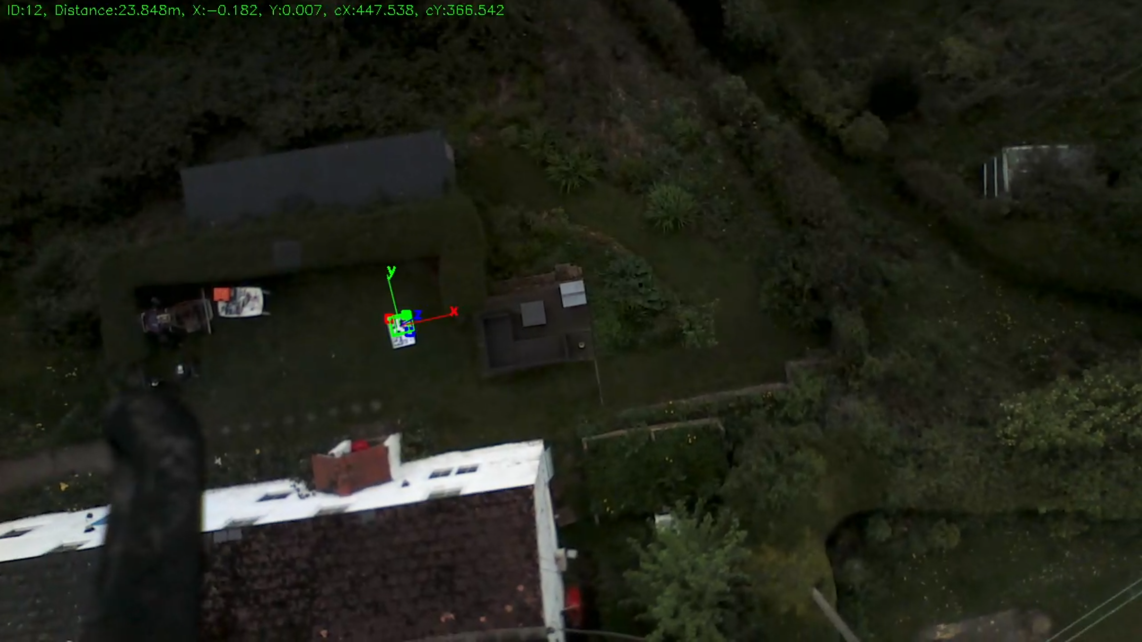
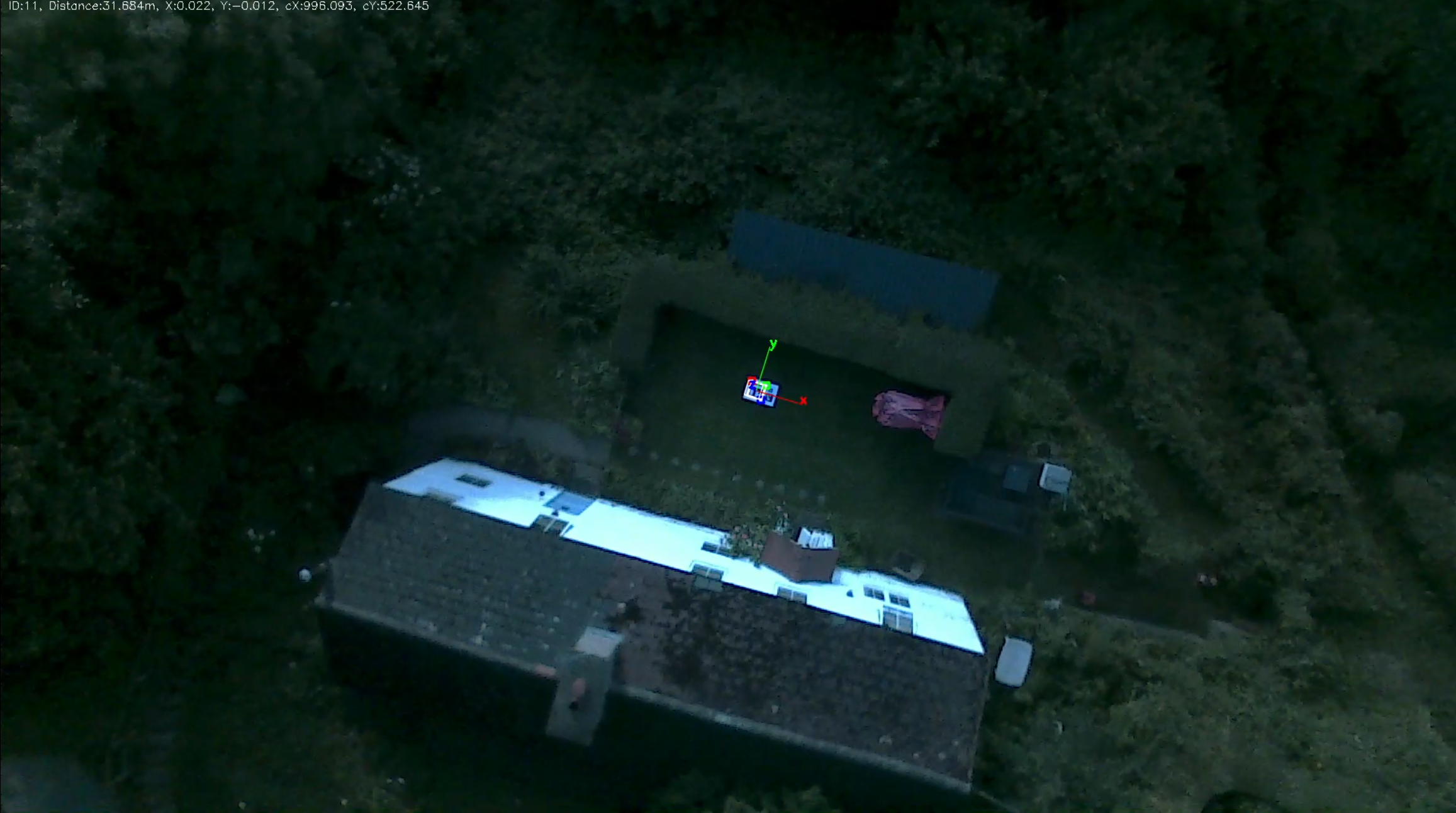
You could use vision based precision loiter for this, quite easily. Your altitude is limited only by the size of the fiducial marker, the resolution of your onboard camera, and the ability of your onboard computer to process the video stream.
If you can print/make a very large marker, then I would expect some decent results. My crude testing a long time I got these results (click on the pictures for fullsize):
As you can see, the quality of the camera/video is impressively terrible and it was still detecting @ 32m (I think it was actually higher than that, the distance detection was buggy back then). Those are A1 boards but because they contain multiple markers for improved landing accuracy the largest marker size is probably smaller than A2. If you were able to for example print a single marker across 4 A1 boards, you would probably get excellent altitude even with crappy cameras.
If you were able to get a 1080p or even 2k/4k video stream with a decent camera, and a fast enough onboard system to process it, together with a larger marker, the sky is your limit