your issue is the projection system. it should be geographic wgs84. the tiff is good, but it definitely is not in wgs84
what system is the 446120.343 and 4244271.201 ?
That did it. Awesome!
Everything works perfectly. The altitude data is perfectly matched with the custom imagery. Fantastic.
Thanks so much for all the help. It’s greatly appreciated.
Now on to the next challenge. We are integrating RTK and would like to change the waypoint radius to something less than 1m, which appears to be the limit. What is required to tighten the waypoint tolerance?
Thanks for everything,
Dave
I seem to be having an issue loading custom geotiff DEM’s. I delete everything in the SRTM folder and copy in a DEM. The DEM is in 4326 and I am using MP V1.3.41 build 1.1.6110.31287. Is there anything about this that is incorrect? I’ve watched Michael’s video from above and don’t see that I’ve doing anything different. However I also cannot figure out how to view the debugging console that he pulled up to show that the Tiff had loaded properly. Any thoughts on how I can go about troubleshooting this? This is a really invaluable feature for what we are doing!
Other thoughts:
Elevation shown is 0m in flight plan screen
To the left of shown elevation is Ocean (??)
I have just been asked the same question and have gone over the instructions.
Michaels video and the quote above seem to be the solution.
A client has the data in a 5m pixel res DEM and wants to use it in Mission Planner.
As I understand it you have to convert your DEM to a geotiff for it to work.
Haven’t verified it yet.
I’m pretty sure that what I am copying over into the SRTM folder is the correct format. However I am not positive. Perhaps if Michael has a chance he could take a look at the file I am using and help me narrow down the issue?
I thought the issue might be the high resolution of the DEM I was using. I downres’d the file I am using to 2m pixels, however I am still having the same issue.
have you opened the debug console? help > show console
if you can show me that I might be able to guess whats going on.
I’ve loaded a GeoTiff (correct projection WGS 84 Lon, Lat) into my srtm folder.
It is the only file within the folder.
However, the elevation data in ‘Flight Plan’ window remains same as Google Earth satellite data.
My GeoTiff appears non-influential, even when in 'Custom’
I’ve opened the debug console,
No warning on GeoTiff & no mention of GeoTiff.
How does one check if the GeoTiff is loaded?
(From Michael - Step 5. Test that the data is loading from the geotiff (How, where?).
Currently running MP 1.3.41
Alan,
In the debug console you should see the file loaded. Look at my post above, which includes a screenshot from the debug console.
Dave
the srtm folder has been moved in newer MP versions.
C:\ProgramData\Mission Planner\srtm
Excellent news from my side.
Michael: When you said 'Look in C:\ProgramData, I could not find your quoted folder.
For me C:\ProgramData did not exist.
I assumed you meant C:\Program Files (x86)\Mission Planner\srtm
However after some frustration, I decided to turn on - show Hidden folders,
and look again…and there it was; the full path C:\ProgramData\Mission Planner\srtm.
I inserted my GeoTiff into this srtm folder, and all is good.
Thanks.
Micheal,
Everything is working great. I have custom imagery with elevation data. Loving it. Wondering about the GEOTiff elevation readout in the upper right corner. I exported my DSM from global mapper with extra precision and I am still seeing elevation data rounded to the nearest meter. Is that the actual altitude the drone will use to fly above when terrain is boxed or is it just displayed to the nearest meter for convenience?
1 meter elevation data is phenomenal but I am wondering if I can get more precision. My DSM is breaking it down to mm accuracy. I don’t expect that but I am hoping to get down to less than a foot. Is that possible?
Thanks for all you do,
Dave
@skyveyor you would be correct. internally I was treating everything as an int. ive just changed it to use floats. So if you provide a 32-bit float geotiff, it should work from the new beta MP today.
dude you are awesome! Thanks for the fast action and response. Seriously, awesome!
Hello Michael,
When attempting to upgrade to the beta version I got an unexpected error. I thought this might be related to how I installed mission planner. So I uninstalled the previous version and installed the current version from the app store to ensure everything was installed in it’s intended place.
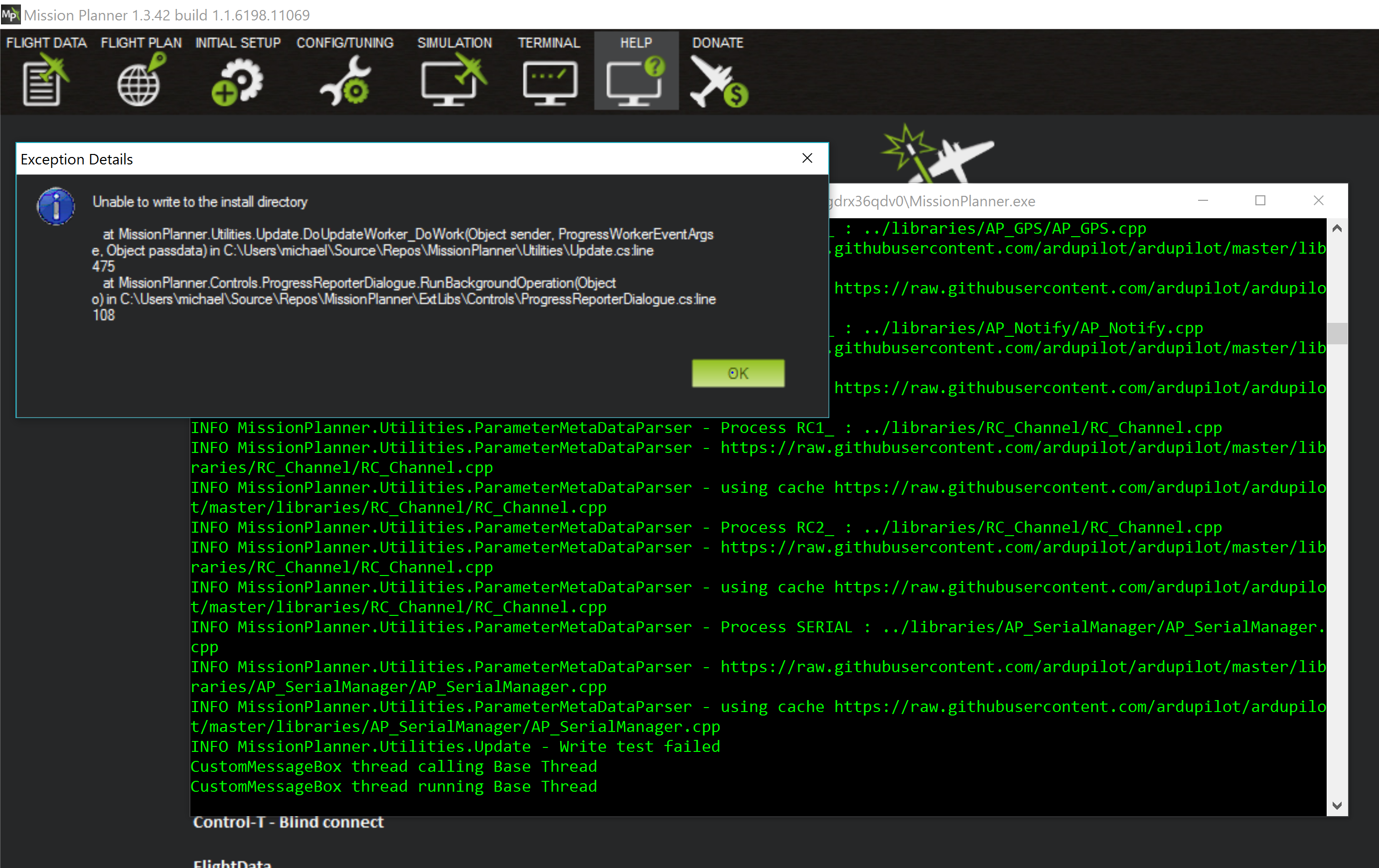
I then tried to to upgrade to the beta version and got the same error.
Any suggestions?
Thanks,
David
I got it to work. Apparently installing it through the app store doesn’t work. I uninstalled it through the app store and reinstalled with the MSI and was then able to upgrade to the beta. In the beta I am seeing centimeter resolution. Freaking phenomenal. Thanks for the great product and amazing support.
Dave
you are correct. the app store has specific things about it. one of them is that you cat modify the install directory.
using the msi etc is the workaround.
Hello Michael,
I am trying to use my custom imagery. My plan was to set up an auto mission with a constant altitude above terrain. I selected terrain and flew the mission, but didn’t notice any changes with terrain elevation. After a bit more reading I see that I am supposed to check for terrain loaded in the mission planner status window. I didn’t know that was a requirement so didn’t check before the flight. Afterwards, I reloaded the mission and looked for terrain; it doesn’t appear to be loading any files. How do I get my custom GEOTIFF into the autopilot? It’s properly loaded in mission planner. I am seeing GEOTIFF with good elevation data. But no indications of any file being loaded when I have terrain selected.
Also, one other related question: If I select absolute as my reference and enter altitudes at each waypoint of 5 meters, what should I see on the flight plan? ASL + 5 or 5? Using an example if my ASL altitude is 200 meters and I want to fly at 205 meters, what should I put in the altitude box 205 or 5?
Thanks,
Dave
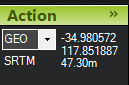
in the latest MP
when you use a geotiff, the alt indicator will say geotiff/srtm/dted etc.
as for absolute. you would need to enter 205.
terrain is above the terrain level loaded from your data source, that is then uploaded to the pixhawk. (this means if you uploaded this before you added your geotiff. the pixhawk could be caching old data.)
absolute is asl
relative is your home point is relative 0
feel free to upload your geotiff somewhere so I can check it out
Michael,
Thanks for your reply. Here is a link to the GEOTIFF. It is loading in mission planner. When I scroll around the image, it clearly says GEOTIFF in the upper right corner. I use this GEOTIFF to create the route of flight for auto missions. I then select terrain and upload the mission to the drone. However it doesn’t appear the map is being uploaded as indicated by the drones flight and status page in mission planner.
Thanks,
Dave