Arduboat Build for Mapping & Water Quality Monitoring

So I’ve been reading on these forums (here and DIYDrones) and have found a lot of cool knowledge and info, its helped answer some questions and spur some creativity! Now, I am trying to get into building arduboats for bathymetry and/or water quality analysis and want to share a design and setup in case it may help someone else with their projects, and to gain any input anyone may want to share.


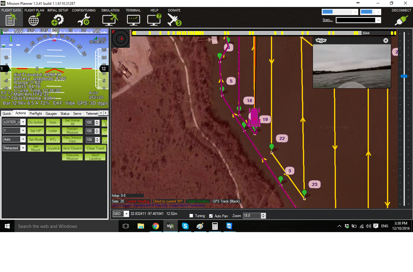
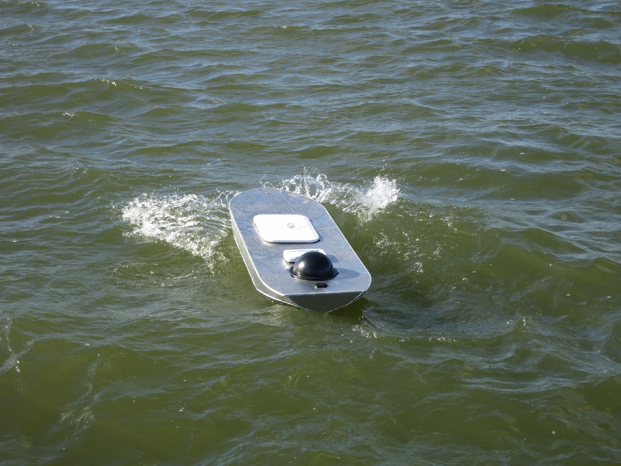
I am calling this one the HarborMaster or perhaps HarborScan. I don’t know for sure yet. It one of 4 designs and my favorite – this one is 6ft long, made of 0.08 5052 Tig Welded Aluminum, is powered by a 30lb thrust trolling motor and dimension engineering Syren controller – of course with Pixhawk with ArduRover firmware.

The telemetry is a 500mw 900mhz link, paired to an on board Windows 10 SOC. The USB side of the telemetry can be plugged into base station laptop for traditional RF-Mission Planner control, or plugged into the SOC which works work with a hotspot and Amazon EC2 instance to relay the signal over cellular. The boat also runs Skype and has a Logitech C920 camera in a 3D printed housing, so in areas with good LTE, very high quality video is possible. When operating with a remote from the video feed, the lag is surprisingly minimal, maybe around 200-400ms.

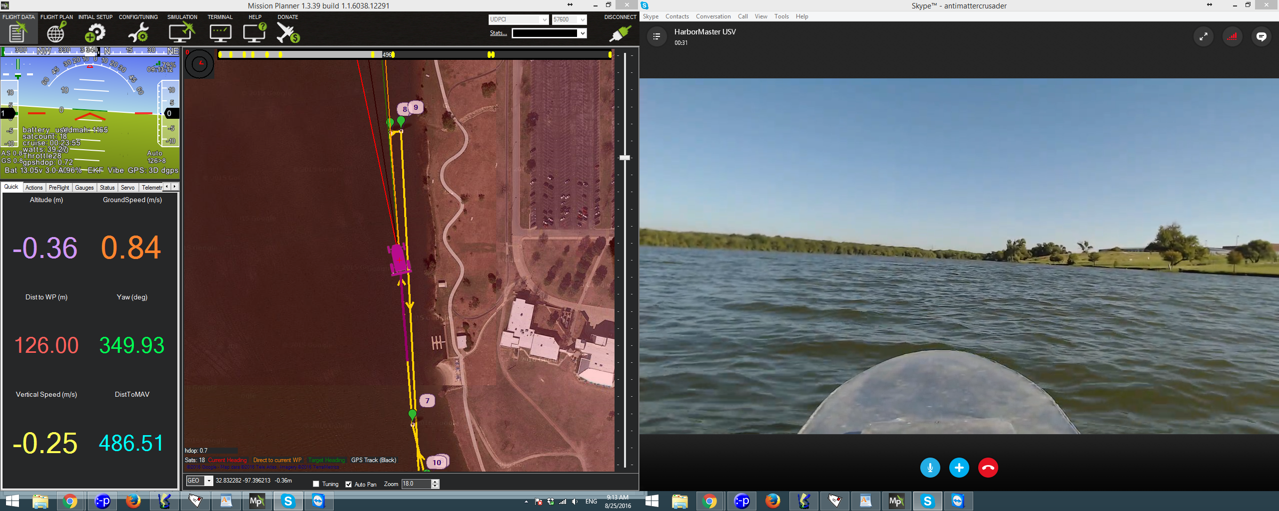
The design is deep/tall with a lot of freeboard, primarily because I wanted to have the option of installing a tall Group 29D 120ah lead acid battery for longer missions, which provides >20hr endurance. That’s a pain to carry though, so typically I use a 40ah 4S LiFeP04 battery which gets around 10hrs.

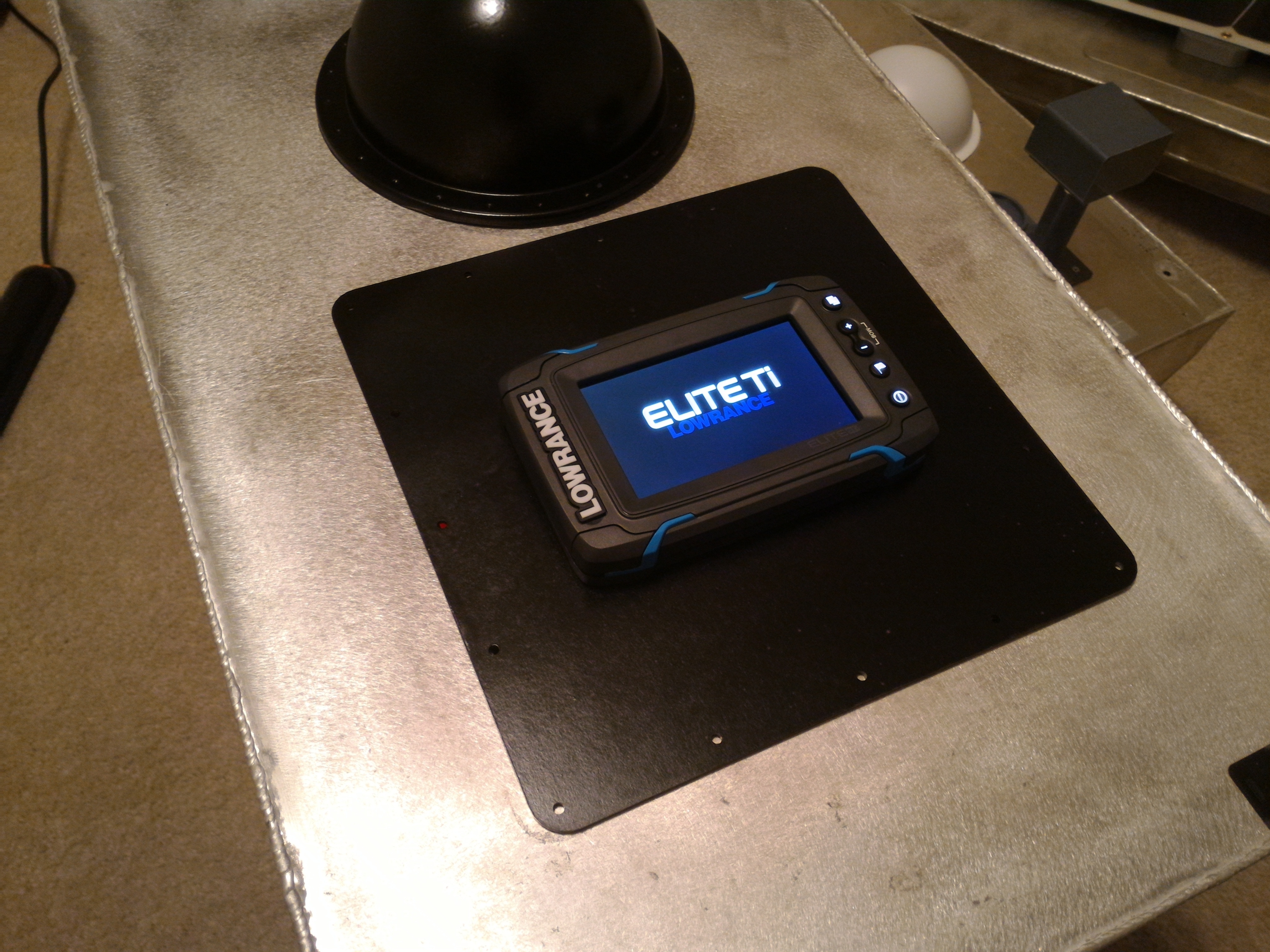
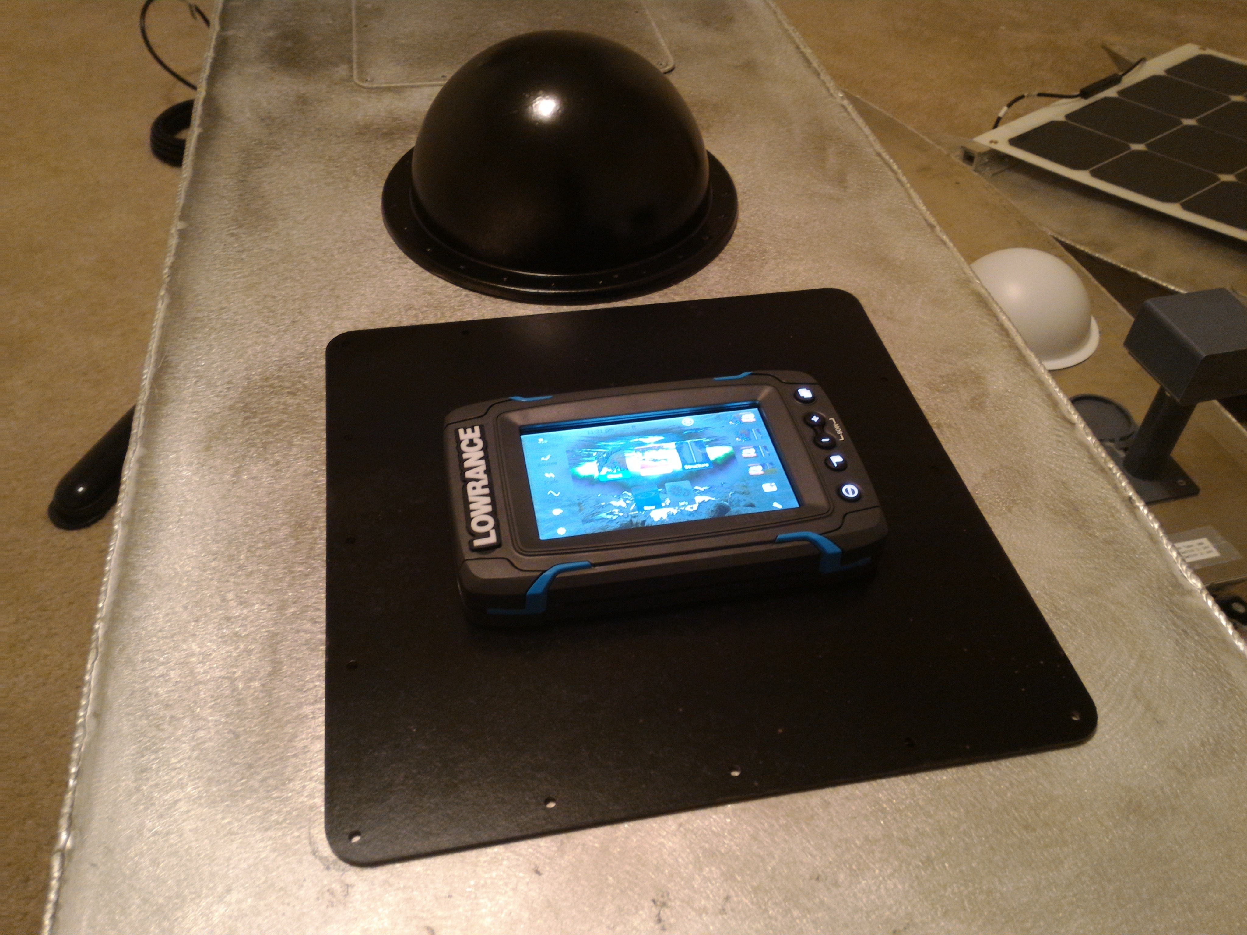
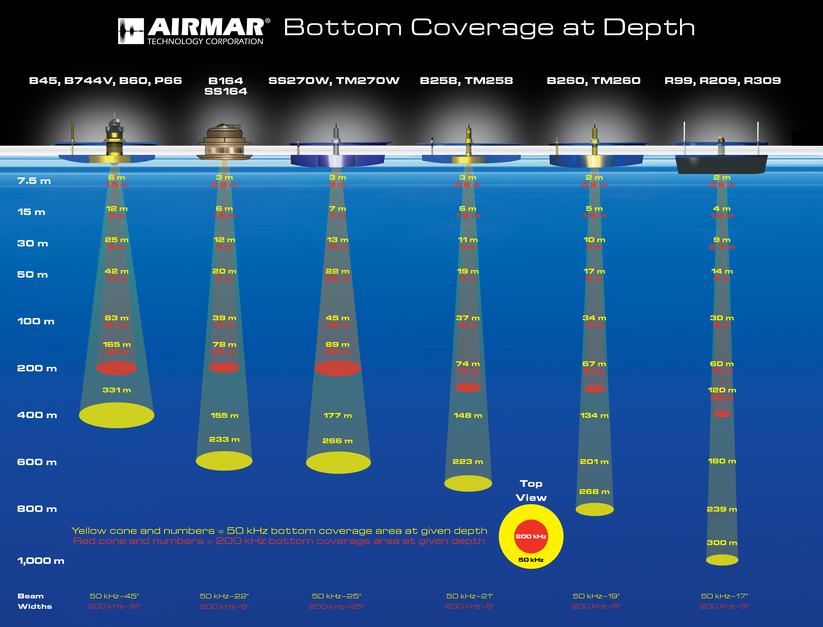
I’ve installed a Lowrance sonar unit and may also add water quality sensors such as dissolved oxygen, ph, conductivity and temperature but this is a new area to me, have some learning to do.

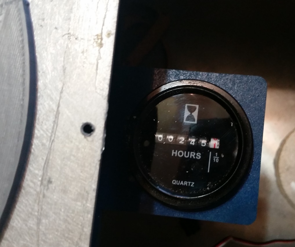
I’ve also installed a 750gph bildge pump just in case there are any issues… it just hit 250 hours on the clock last weekend, so far so good, no breakdowns - though I did run the battery dead once and one time getting stuck in a thick patch of seaweed.

Anyway, if anyone has any suggestions, or has any questions on the setup, wants to bounce ideas around – post here! Happy to share and learn.

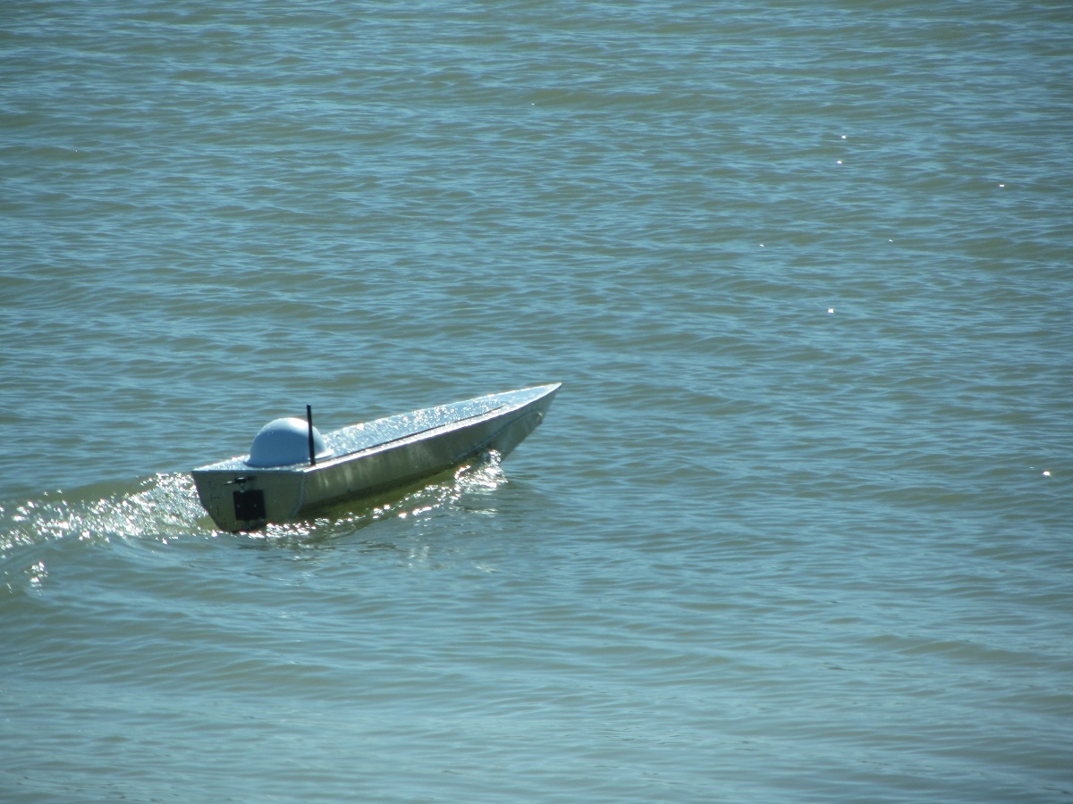
Here are some pics of other designs, which is not as well tested yet, but so far seem to perform well!


7 Likes

Great looking boat. Got any videos?

Thanks, Grant.

Thanks, I don’t have any from the shore, but have recorded a few from the boat:

This was only the 2nd time out…I’ve since replaced that metal lid with a marine grade watertight hatch! lol

@antimattercrusader Love your work, what’s the new website so I can bookmark it?

When you get a chance, can you write up a tutorial on how you did the 4G and Amazon EC2 instance? I know you described it a bit on Eddie’s thread, but I don’t want to clog his up too bad.

I think your method is the way to making USVs a part of the “Internet of Things” where we can access them anywhere and a path towards sat comms. Luckily for us boaters, we don’t have to worry about LOS restrictions like the aircraft guys do and we can do much longer ranges.

Also, what LiFePO4 battery are you using?

That is a great looking boat. Seems to run very well. Thanks for the videos!

Thanks, Grant.

I didn’t get much interest in hulls only but do think ready to go systems has some potential. I actually build primarily aircraft but am looking to cross over, www.autonomousaeronautics.com. I’m going to be doing an update soon and adding a smaller briefcase sized easy to carry flat bottom boat instead of the pondscan which has too much roll, maybe getting rid of the “pro” versions etc, doing that type of stuff as custom projects should there be any interest. Probably will reduce the price and endurance of the HarborMaster… I am not seeing people needing a 30hr endurance. So no need for that expensice 180ah battrry. Probably will add an affordable RTK upgrade which interfaces to the sonar. Any input is welcome!

Sure, I’ll type up a write up here over the next few days and post it.

These are the batteries I used: http://www.batteryspace.com/lifepo4-prismatic-module-3-2v-40-ah-10c-rate-128-wh-----un38-3-passed-dgr.aspx

However, I had them laying around. I’d go with a bigger pack for a boat of this size otherwise. Maybe 60-100ah. The 40ah seems to have a 10hr endurance. I also like the 16ah 4s Multistar Lipos, these give great endurance to smaller boats. They don’t deal with harsh conditions as well though.

Great looking boats though! My recommendation for the boat side of your business is to have a base working boat and then have a drop down menu for customers to add what sensors they would like (can be as many as they want). That way it’s a little bit more than an all or nothing.

I’m also of the opinion that RTK is a bit more than we need for boats unless we are doing really small water volumes. The single beam swaths kinda take out the accuracy of it. but if you want to do it, the GPS/RTK for the Pixhawk 2 looks like it might be a good choice. I intend on upgrading and putting a GPS 1 and 2 on my next one.

Thanks for being willing to do the write-up! I’ve already registered for an AWS account so I can go try it out.

I’ve looked into those batteries before, so I’m glad you’ve tested them. I might have to get a few and build a pack.

UBLOX has their M8P RTK GPS modules available. Integration is continuing with ArduPilot but we hope by the new year these will provide a decent cheaper RTK alternative.

Thanks, Grant.

That’s a good idea to have the options for customers, for the aircraft as well.

I think you are correct and probably know more than me about the sonar aspect of this. Correct me if I am wrong, but my understanding is that the angle of spread on the beam on these units is pretty wide and it will record the closet return, so as it gets deeper, it fans out more and gets less accurate? So, these sonar units are better for shallower conditions only? If so, do you know what the useful depth range is (subjective, I am sure, but any thoughts are appreciated!) Also, do you know of any higher end single beam systems for deeper areas? I’ve been looking at the Chinese HD370s, some teledyne equipment, Ceescope, Hydrobox etc, but am out of my element on these at this time - still alot to learn.

Hi there, this is a most interesting discussion.
I am primary focussed on aerial mapping when it comes to Ardupilot, but my other job is hydrographic surveyor. I agree with the choice of bathy/sonar units to propose, from yachting to survey grade.
RTK is mainly used for tidal reduction of bathymetric measurement. And now with PPK techniques (Post Processed Kinematic), we can avoid to bother with real time transmission of correction and focus on raw data recording. You have cheap components such as Emlid Reach which does a very good job in recording L1 phase data, and post process can really give you centimetric level accuracy.
On the sensor side, we usually work with five main types of equipments:

  • single beam echosounder
  • multi beam echosounder
  • side scan sonar
  • sub bottom profiler (low frequency pinger, to see sediment heights below bottom)
  • magnetometer (wreck / pipe / debris detection)
    Each line can be a subject of discussion by itself. But survey grade sensors can easily go to several 10k USD. And your typical client would be used to pay that much for a single sensor.
    I would be happy to help if you need more specific infos.
    One last thing : you should go for high visibility colors in place of grey.

Pascal

You are correct, all the singlebeam (and singlebeam CHIRP) transducers have a certain beam angle, measuring the closest return. The depth that can be reached is related to how much energy the sonar can put into the water.

Here’s a graphic on some general Airmar transducers to illustrate the point:

If you want to put a higher power single beam system that is still compatible with Reefmaster, I’d take a look at some of the Garmin sounder (black box) and transducer combinations. That should get you down pretty deep. Unfortunately, the Garmin side scan is not compatible with Reemaster yet, or else that would be my go-to system.

If you really want the high end stuff…yeah I’m out of my element there too, I try to keep things affordable :slight_smile:

Thank you both for the input. It’s greatly appreciated. I’m about 20% done with that cellular telem write up!

@Pascal_P I will pick your brain a bit more later about the different payloads. Thanks!

1 Like

Subscribed. Really like this build and discussion so far.

I am building a bathy mapping platform but for really small shallow lakes/ponds for habitat restoration studies. I am trying to research the options for sonar and have decided that the consumer grade aren’t going to cut it for me (I hope I am wrong and am still researching) but am looking now at single beam echosounders under 5k USD and found:
http://www.echologger.com/products/6 (if anyone has experience with this unit or company I would love to hear it)
the vendor quoted around 3k USD so might be a good option to pair with a raspberry pi as a datalogger running RTKLIB for location accuracy.

I am not currently planning to collect water quality data but that is what my experience is in - I have been using water quality dataloggers in estuarine, fresh and saltwater environments for many years so have some info on different sonde and/or sensor options and communication if needed.

Look forward to more updates on your project.

Michelle

@Michelle - Thanks for the link. I don’t have any experience with this company, but it looks interesting to say the least. Look forward to learning more about this option.

Was looking at their software and notice they have a com port option for GPS - probably would pair up easily with the reach RTK system for affordable high accuracy.

Any info you can provide about water quality sensors is greatly appreciated! I was looking at the insitu troll sensors and atlas scientific.

So, today I took the boat out on a mock bathy survey with a Lowrance Elite 5TI. Using the cellular telemetry, conditions at the control site couldn’t be better:

:smiley: But in reality, conditions on the lake were rough, about 35-45 degrees, 15-25mph winds and waves which came over the top of the bow – with occasional whitecaps - which caused quite a bit of pitch and roll action. The data appears to be skewed accordingly. I covered the majority of Marine Creek reservoir (near Lake Worth, TX) in around 3-4hrs.

The raw sonar results can be downloaded here, let me know your thoughts: https://drive.google.com/open?id=0B0zckiBiKbEiRjdYSEt2TWNLU2s

Here is a video of about one and a half hours of the mission, taken with the boat’s on board camera: https://youtu.be/YB9CYVWNDAY?t=9m

You’ll notice that the boat lists after a while, I stopped and checked it out. I ran out of auxiliary connectors so instead of adding a new circuit, I just tossed a 20ah 4s battery in there to power the sonar unit, which was not secured. Nor was the sonar unit itself (I have a mounting plat which was not on the boat – this was a spur of the moment thing) so all that stuff slid to one side and caused the list.

Lessons: Unless just having fun, better weather is probably needed for decent data. Secure things better. Don’t forget to activate side scan recording! Also, realized doing this at night is nice, less boats, traffic, etc – I will add a bow navigational light and a Cree light on the camera pod later.

2 Likes

As I’ve reviewed fruther the sonar file, I’ve noticed a few things:

The track is not at all straight. However, the boat (from watching it, and on the video, appear to be maintaining a pretty straight track) as doe the track on Mission Planner


Perhaps this i because I put the sonar unit inside the boat for today’s run? Perhaps it did not have a good GPS lock? Any thoughts?

The Depth is not as consistent as I would have thought, in areas where it overlapped, for example on one spot, first pass said 7.88M and the next was 8.18m. Perhaps it was from the rough water, it was getting a return at a different angle? The 2nd pass in this case was running side ways to the wave so roll was severe. Any thought?

Thanks for any input!

It’s probably a combination of the sonar display (with internal GPS) being inside a metal hull and your USV rolling/pitching/heaving pretty bad. I used a Lowrance HDS-7 Gen 3 for my build and I had straight tracks. Maybe an externally mounted GPS would get you better results.

I’d recommend retrying the run when it is calmer. Due to paddleboarders in my areas, I had to wait until dusk to do my mappings as well to avoid collisions and have straight tracks.

The other idea I’m thinking about is somehow getting the NMEA GPS/Depth stream back to a shore based Reefmaster so we can do live mapping from our control area. This will enable us to see in real time how our measurements are coming in so we can evaluate the quality. I haven’t figured out the equipment need to do this yet, but its definitely an area of research.

Ok, thanks for the input. I have two mounting plates, one for a camera pod and one for the sonar unit, which places it on the outside of the boat. I imagine the head unit being inside was the issue as the other tests I’ve done (with the head unit outside) did not have that issue.


vs

I have deigned a new plate which mounts both the sonar and camera pod, will cut it next time I’m cutting things.

Anyway, yes, I will run it again during some reasonable conditions.

Regarding your idea to have the stream back to your shore station, I have a few thoughts, maybe worth something, maybe not…

Check this out from carplounge: http://www.carplounge.de/en/fischfindergps They’ve somehow managed to make the link from the transducer to the head unit wireless. While that’s not what you’re looking for exactly, it’s half the battle and implies the transducer uses some sort of data stream that might be hackable? Plus perhaps the head unit can output a NEMA stream connected to a serial port…I noticed reefmaster can accept a COM port. Take a look at this document: http://cms.nobeltec.com/CMS/Files/Connecting%20instrument%20serially%20to%20the%20computer.pdf

My next thought is using the Gofree API - they do allow 3rd party apps to tap into the Lowrance systems via wifi/bluetooth. Maybe a raspberrry pi or similar can take that bluetooth/wifi data and send it over a USB RF link which is recognized by your computer as a COM port. Or over the internet for that matter (exceeds my abilities though)

Finally, those transducers which Michelle referenced (Which I am actually excited about, looking into them)… You could connect that to a computer on the boat running Reefmaster, or I am sure it could be hooked to a radio and fed wirelessly to reef master. This company has a lot of wireless solutions to get data from A to B: http://www.microhardcorp.com/

Hope any of this helps!

@Kevin_K One other thing I’d like to get your input on… I was looking at designing an underwater active brushless gimbal system to keep the transducer flat, as long as the boat is < 30 degrees roll/pitch, the transducer would remain flat.

The totalscan transducer is a challenge for this design, especially for pitch axis due to its length and huge cable (but I think it might be worth the effort for smooth sidescan data even in semi-rough conditions) The Echo Logger is small and perhaps perfect for such a thing!

That said, with your experience, what are your thoughts on this?

Good looking mounting plates. I’m interested to see the combined plate, it should look pretty good and get everything you want.

I’m thinking the answer for the NMEA data steam back to shore is a bit of your #1 and #2 ideas. I’m thinking of doing a hard wire serial connection from whatever sonar unit/chartplotter we are using into the Raspberry Pi we are already using for the Mavlink comms. On the RPi, we load up a program called OpenCPN, which is able to take NMEA inputs and output NMEA over TCP/UDP: http://opencpn.org/ocpn/options_connections From here, we have it piggy back on the cellular/wifi connection to the AWS server, and then finally do some magic on the shore computer side to translate that to something Reefmaster can read (virtual COM port?). That’s about as far as I got.

Yes, there a few underwater brushless gimbals out there, but I have a few concerns about using them. I operate in salt water so I’m not sure how long they would last for me. Might be fine for you in freshwater. A gimbal is also going to have A LOT of drag. It might make sense if there could be a sort of “moon pool” in the hull to hide the gimbal but still have the transducer in clear water and free to rotate. I don’t know, it would be an interesting engineering challenge. For me, I’m find with hard fixed mounts. Less accurate results, but less of a headache for ocean mapping. If anything, I just use a bigger vehicle.